How to prepare for earthquakes: rules of survival August 20, 2021, 08:45
The Department of Emergency Situations of the Almaty region spoke about the rules of behavior during an earthquake, reports.
According to rescuers, if you prepare for earthquakes by studying the rules of behavior in advance, you can significantly reduce all possible risks of accidents.
How to prepare for an earthquake?
First , think in advance about an action plan during an earthquake while at home, at work, in a car and on the street. Explain to your family members what they should do during an earthquake, who, where and how should turn off electricity, water, gas, and teach them the rules of first aid.
Second , keep documents, money, a flashlight, spare batteries, a first aid kit, personal hygiene items, a transistor radio, spoons, knives, matches and food in a convenient place, preferably in a backpack at the exit of the apartment.
Have at home a supply of drinking water, a portable flashlight, a fire extinguisher, a first aid kit and enough canned food for several days.
Third , move beds away from windows and outside walls. Secure cabinets, shelves and racks in apartments, and remove heavy objects from the top shelves. Place furniture so that it cannot block exits from rooms or block doors.
Fourth , store hazardous substances (toxic chemicals, flammable liquids) in a safe, well-insulated place where they cannot break or spill.
Fifth , agree with your neighbors on mutual assistance and joint actions in case of emergencies. — Know the gathering place and evacuation procedures. — A garage or a summer house can be used as a temporary shelter in the first days after a strong earthquake. Keep food supplies and spare items there. As a family, periodically conduct conversations and training in case of an earthquake.
What to do during an earthquake?
First , quickly leave the building, taking documents, money and essentials. When leaving the premises, take the stairs rather than the elevator. Once outside, stay there, but do not stand near buildings, but move to an open space.
Second , stay calm and try to reassure others. If you are forced to stay indoors, then stand in a safe place: near an internal wall, in a corner, in an internal wall opening or near a load-bearing support.
If possible, hide under a table to protect you from falling objects and debris. Stay away from windows and heavy furniture. If you have children with you, cover them with yourself. If you are in public places, behave calmly, do not create panic, do not rush to the exit and do not create traffic jams in the way of people, help the sick and disabled.
Third , do not use candles, matches, or lighters - if there is a gas leak, a fire may occur. Stay away from overhanging balconies and cornices, and beware of downed wires. If you are in a vehicle, remain in an open area, but do not leave the vehicle until the shaking stops. Be prepared to assist in rescuing other people.
What to do after an earthquake?
First , be careful! Ensure the safety of children, the sick, and the elderly. Calm them down. Don't use your phone unless absolutely necessary. Turn on the radio broadcast. Obey the instructions of local authorities and disaster response headquarters.
Second , do not approach or enter obviously damaged buildings. Be prepared for strong aftershocks, as the first 2-3 hours after an earthquake are most dangerous. Do not enter buildings unless absolutely necessary.
Third , do not invent or broadcast any rumors about possible aftershocks. Use official information.
Fourth , if you find yourself under rubble, then assess the situation and, if possible, provide yourself with medical assistance. Try to establish contact with people outside the rubble (voice, knock). Remember that you cannot light a fire, but pipes and batteries can be used to give a signal. Save energy. A person can go without food for more than half a month.
On August 21, 2021, at 12.00, the Department of Emergency Situations of the Almaty Region, in order to conduct a technical check of the regional warning system in the event of an emergency, will turn on electric sirens with the “ATTENTION ALL” signal for 30 seconds.
If the signal finds you at home: - turn on the radio, radio broadcast and television receivers; — listen to an emergency message; - act in accordance with the transmitted message. If the signal finds you on the street: - listen to the emergency message transmitted by street loudspeakers and mobile warning devices; - act in accordance with the transmitted message.
“The Almaty region is located in a seismically active region of the republic, where strong earthquakes are possible. According to statistics, up to 400 tremors of the earth's surface are recorded annually in the region, without being felt on the surface of the earth.
On August 18, residents of Kapshagai felt an earthquake. The epicenter of the earthquake was located 78 kilometers north of Almaty, near the city of Kapshagay, Almaty region. The energy class of the earthquake is 9.6. Magnitude - 4.9. Depth - 20 kilometers.
This was the third report of tremors on August 18. Two other earthquakes also occurred in the Almaty region. In the city of Zharkent, the tremors were felt with a force of 5 points, in Taldykorgan and the village of Saty - with a force of 2-3 points.
HOW TO PREPARE FOR AN EARTHQUAKE
· Think in advance about an action plan during an earthquake while at home, at work, in the cinema, theater, on transport and on the street. Explain to your family what they should do during an earthquake and teach them first aid.
· Keep documents, money, a flashlight and spare batteries in a convenient place.
· Have a supply of drinking water and canned food at home for several days.
· Move beds away from windows and outside walls. Secure cabinets, shelves and racks in apartments, and remove heavy objects from upper shelves and mezzanines.
· Store hazardous substances (toxic chemicals, flammable liquids) in a safe, well-insulated place.
· All residents must know where the switch, main gas and water taps are located in order to turn off electricity, gas and water if necessary.
HOW TO ACT DURING AN EARTHQUAKE
· When you feel the vibrations of the building, see the swaying of lamps, the fall of objects, hear an increasing rumble and the sound of breaking glass, do not panic (from the moment you feel the first tremors to the vibrations that are dangerous for the building, you have 15 - 20 seconds). Quickly exit the building, taking documents, money and essential items. When leaving the premises, take the stairs rather than the elevator. Once outside, stay there, but do not stand near buildings, but go to an open space.
· Stay calm and try to reassure others! If you are forced to stay indoors, then stand in a safe place: near an internal wall, in a corner, in an internal wall opening or near a load-bearing support. If possible, hide under a table to protect you from falling objects and debris. Stay away from windows and heavy furniture. If you have children with you, cover them with you.
· Do not use candles, matches, or lighters - a gas leak may cause a fire. Stay away from overhanging balconies, cornices, parapets, and beware of downed wires. If you are in a vehicle, remain in an open area, but do not leave the vehicle until the shaking stops. Be prepared to assist in rescuing other people.
HOW TO ACT AFTER AN EARTHQUAKE
Provide first aid to those in need.
Free those trapped in easily removable rubble.
Be careful! Ensure the safety of children, the sick, and the elderly. Calm them down. Don't use your phone unless absolutely necessary. Turn on the radio broadcast. Obey the instructions of local authorities and disaster response headquarters.
Check for damage to the electrical wiring. Fix the problem or turn off the electricity in the apartment. Remember that during a strong earthquake, electricity in the city is automatically turned off.
Check for damage to gas and water lines. Fix the problem or disconnect the networks. Do not use open flames. When going down the stairs, be careful and make sure they are strong.
Do not approach or enter visibly damaged buildings. Be prepared for strong aftershocks, as the most dangerous are the first 2 to 3 hours after an earthquake.
Do not enter buildings unless absolutely necessary. Do not invent or broadcast any rumors about possible aftershocks. Use official information. If you find yourself trapped, calmly assess the situation and, if possible, provide yourself with medical assistance. Try to establish contact with people outside the rubble (voice, knock). Remember that you cannot light a fire, you can drink water from the toilet tank, and pipes and batteries can be used to give a signal. Save energy. A person can go without food for more than half a month.
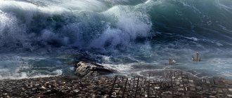
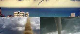
5. Tsunami: causes, characteristics, protection.
Tsunamis are caused by sudden vibrations of the earth's crust under the ocean floor. The most destructive tsunamis are usually caused by earthquakes. In addition, the cause could be a volcanic eruption, a landslide, or even a comet falling into the ocean.
Landslides cause tsunamis when a huge mass of destroyed rock falls into the water. The resulting effect is reminiscent of the effect of throwing a large stone into a puddle, when a chill runs through the puddle and waves flow. But when this happens in the sea, where thousands of tons of rock and earth fall, a huge wave appears, resembling a tidal wave. It moves across the sea and finally reaches land, where it turns into a tsunami wave.
A volcanic eruption can also cause a tsunami. In this case, the volcano can be located on land or under water - the so-called “underwater volcano”. If a volcano erupts on land, a tsunami occurs when lava and rock debris enter the ocean, causing a large wave.
If an eruption occurs under water, then this powerful explosion leads to vibrations of the earth's crust and breaks the water column. This creates huge waves that travel across the ocean until they meet land on their way. And then the tsunami begins.
___________________
Propagation speed up to 100 km/h up to 1000 km/h. Wavelength up to 0.5 km to 1000 km. Period up to 20 seconds up to 2.5 hours. Penetration depth up to 300 m, to the very bottom. Wave height in the open sea is up to 30 m to 2 m. Wave height off the coast is up to 40 m to 70 m.
The main characteristics of a tsunami are: magnitude, intensity on a particular coast and wave speed.
The tsunami magnitude is taken to be the natural logarithm of water level fluctuations (in meters), measured by a standard tide gauge near the coastline at a distance of 3 to 10 km from the tsunami source. Tsunami magnitude, unlike earthquake magnitude, characterizes only part of the tsunami energy (which itself is part of seismic energy).
Tsunami speed is the distance a tsunami travels in a certain time.
Wave height is the vertical distance between the crest and trough of the wave.
Wavelength is the horizontal distance between two peaks or troughs of sea waves.
Wave period is the time interval between the arrival of two successive waves.
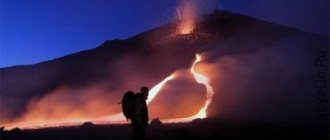
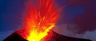
6. Volcanic eruptions: types of volcanoes, causes of eruptions, protection.
Volcanoes are classified:
by shape (shield volcanoes, stratovolcanoes);
activities (active, dormant, extinct);
location (terrestrial, underwater, subglacial) and others.
vent crack
This is a type of volcano with a flat fault at the top in the form of a line through which lava erupts.
Shield volcano
This type of volcano is named because of its wide shield-shaped profile, formed by the eruption of inviscid lava, which can spread over long distances from the fissure, but this generally does not lead to catastrophic consequences. Non-viscous lava does not contain much silica, so shield volcanoes are found primarily in the ocean rather than on continents.
Lava dome
Lava domes are formed by the eruption of inviscid lava. Sometimes they form in the crater of a volcano that erupted some time ago, as at Mount St. Helens, but they can also be formed independently of previous eruptions, as in the case of Lassen Peak. Just like stratovolcanoes, they are accompanied by strong explosive eruptions, but their lava generally does not spread far from the hydrothermal corridor.
Cryptovolcanoes
Cryptovolcanoes form when viscous lava pushes its way upward and causes a lava cone to form. The volcanic eruption of Saint Helena in 1980 was an example of a cryptovolcano. The lava was under enormous pressure and formed a lava dome on the top of the mountain, which was unstable and therefore flowed down the northern slope.
Slag cone
Volcanic or cinder cones are formed by the eruption of small pieces of cinder and pyroclasts (both of which look like small cylinders, which give the volcano its name) forming around a hydrothermal corridor. The eruption occurs for a fairly short time and forms a cone-shaped hill 30-40 meters high. Most cinder cones erupt only once. They can form as end hydrothermal corridors on large volcanoes, or form on their own. Paricutin in Mexico and Sunset Crater in Arizona are examples of cinder cones. In New Mexico, about 60 cinder cones were formed on the Caja del Rio volcanic field.
Stratovolcanoes
Stratovolcanoes, or compositional volcanoes as they are also called, are characterized as tall conical structures consisting of layers of lava and other products of a volcanic eruption, the so-called layers - strata - which gives the name to this type of volcano. Stratovolcanoes are formed from cinder, ash and lava. As a result of volcanic activity, slag and ash settle on the top of the mountain in layers (ash on top of slag), and lava flows down the ash layer, where it cools and hardens, and then the process is repeated. Typical examples of stratovolcanoes are Mount Fiji in Japan, Mavon Volcano in the Philippines, and Mount Vesuvius and Stromboli in Italy.
Supervolcanoes
A supervolcano is usually characterized by a caldera spread over a vast area, which can potentially pose a huge danger, sometimes even on a continental scale. Eruptions of such volcanoes can cause severe global cooling, lasting for several years in a row, as a result of the release of huge masses of sulfur and ash into the atmosphere. A supervolcano is the most dangerous type of volcano. Examples include Yellowstone Caldera in Yellowstone and Valles Caldera National Park in New Mexico, Lake Taupo in New Zealand, Lake Toba in Sumatra and Ngorogoro Crater in Tanzania, Krakatoa near Java and Sumatra. A difficult task for volcanologists is determining the boundaries of the huge calderas of supervolcanoes, the territory of which has expanded over the centuries. Vast regions of volcanic origin are also characterized as supervolcanoes if they are covered by huge layers of erupted basaltic lava, but they are considered incapable of volcanic activity.
Underwater volcanoes
It is well known that underwater volcanoes are located on the ocean floor. Some of them are active at shallow depths and can be determined visually by the eruption of steam and rocks above ocean level. However, many are located at great depths, where huge masses of water prevent steam and gases from erupting to the surface. However, it is possible to determine the activity of such volcanoes using underwater vehicles and the discoloration of water on the surface, which occurs due to the chemical processes of combining water with erupting gases.
Pumice may also be a product of an eruption. However, even a large eruption does not disturb the ocean surface in any way due to the rapid cooling process of the eruption products in water, in relation to gases in the atmosphere; water also reduces the rate of spread of volcanic materials. Submarine volcanoes often form columns above a hydrothermal corridor. Such columns can become so tall that they can appear above the surface of the oceans and form new islands. Lava underwater forms into balls, which is a typical characteristic of underwater volcanoes. Hydrothermal corridors are often found near such volcanoes and even support a separate ecosystem built on walls of molten minerals.
Mud volcanoes
Mud volcanoes or mud cones are usually formed by the eruption of liquids and gases, although there are some other processes that can lead to the formation of such volcanoes. The largest mud volcanic structure is 10 kilometers in diameter and about 700 meters high
Subglacial volcanoes
Subglacial volcanoes form under ice caps. The erupted lava flows over large lava boulders and basaltic tuff that were formed by previous volcanic eruptions. During such eruptions, the ice caps melt and the lava at the top goes down, leveling the surface and forming a flat top. Such a volcano is also called flat-topped or thuja. Typical examples are the mountains of Iceland, as well as British Columbia. Flat-topped volcanoes were first explored there, in the Tuia River and Tuia Range in northern British Columbia. Tuya Butte - the natural landscape was first explored by volcanologists and gave its name to this group of volcanoes. Tuia Mountains National Park was also recently created in the northern region of Lake Tuia and south of the Jennings River near the Yukon Territory to protect a rare landscape of subglacial volcanoes.
_________________________
The cause of a volcanic eruption is the release of gases contained in the magma: when rising from the bowels of the Earth, they expand, thereby catalyzing explosions (a quick release is a strong explosion, a slow release is a weak explosive manifestation).
________________________________________
To ensure the protection of the population from the consequences of volcanic eruptions, constant monitoring of the precursors of this phenomenon is organized. The harbingers of an eruption are volcanic earthquakes, which are associated with the pulsation of magma moving up the supply channel. Special instruments record changes in the slope of the earth's surface near volcanoes. Before an eruption, the local magnetic field and the composition of volcanic gases released from fumaroles (places where volcanic gases emerge on the Earth’s surface) change. In areas of active volcanism, special stations and points have been created where continuous monitoring of volcanoes is carried out. A reliable system is being organized to alert the management bodies of industrial enterprises and the population about the threat of a volcanic eruption. At the foot of volcanoes, the construction of enterprises, residential buildings, roads and railways is prohibited, and blasting operations are prohibited. The most reliable way to protect the population from the consequences of a volcanic eruption is evacuation. If you receive a signal about the threat of a volcanic eruption, you must immediately leave the building and arrive at the evacuation point.
7. Floods: types, types, causes, protection of the population from floods.
Flooding is an increase in the water level of a watercourse, reservoir or groundwater, leading to the formation of a free surface of water in a section of the territory. There are long-term floods, in which the economic use of flooded lands is impossible or impractical, and temporary floods, in which the use of flooded lands is possible and advisable.
Floods are an annually recurring seasonal long-term and significant increase in the water content of rivers, accompanied by an increase in the water level in the riverbed and flooding of floodplains.
Flood is a phase of the water regime of a river, a relatively short-term and non-periodic rise in the water level in the river, resulting from the rapid melting of snow, glaciers, and heavy rains.
Ice jam is an integral part of the freezing process of the river and occurs in the fall due to slush - loose pieces of inland ice and wet snow that formed in the upper sections of the river.
An ice jam is an integral part of the process of breaking up a river, an ice dam on a river.
Flood classification:
1. storm (rain);
2. floods and floods (associated with melting snow and glaciers);
3. gluttony and congestion (associated with ice phenomena);
4. blockage and breakthrough;
5. surge (wind on the coasts of the seas);
6. tsunamigenic (on the coasts from underwater earthquakes, eruptions and large coastal landslides).
River floods are divided into the following types:
1. low (small or floodplain) - low floodplain is flooded;
2. medium - high floodplains are flooded, sometimes inhabited or technogenically cultivated (arable lands, meadows, vegetable gardens, etc.);
3. strong - terraces with buildings, communications, etc. located on them are flooded, often requiring evacuation of the population, at least partially;
4. catastrophic - vast areas are significantly flooded, including cities and towns; emergency rescue operations and mass evacuation of the population are required.
Anthropogenic causes of floods:
Direct causes are associated with various hydraulic engineering measures and the destruction of dams.
Indirect - deforestation, drainage of swamps (drainage of swamps - natural runoff accumulators increases runoff to 130 - 160%), industrial and residential development, this leads to a change in the hydrological regime of rivers due to an increase in the surface component of runoff. The infiltration capacity of soils decreases and the intensity of their washout increases. Evapotranspiration is reduced due to the cessation of interception of precipitation by the forest floor and tree crowns. If all forests are removed, the maximum flow can increase to 300%.
There is a decrease in infiltration due to the growth of impervious pavements and buildings. The growth of waterproof coatings in urbanized areas increases floods 3 times.
Human activities leading to floods:
1. Restriction of the living cross-section of the flow by along-channel roads, dams, and bridge crossings, which reduces the channel's throughput capacity and increases the water level.
2. Disruption of the natural regime of flows and water levels, as happens in the lower Volga as a result of seasonal regulation of flow by overlying reservoirs: the need for winter energy forced a 2-3-fold increase in water flows in winter, which, in the presence of ice cover, is accompanied by an increase in water levels (winter floods), often above high water levels.
3. Development of territories in the lower reaches of reservoirs for long-term flow regulation. Economic development of floodplains increases the maximum flow.
___________________________________________
If you hear a flood warning:
· - turn on the TV or radio, they may receive important information. In the prescribed manner, exit (drive) from the danger zone of possible catastrophic flooding to a designated safe area or to elevated areas;
· - inform neighbors and loved ones located in the area of the phenomenon about the threat;
· -prepare documents, valuables, medicines, a 2-3 day supply of non-perishable food, bed linen and toiletries, if possible a set of outerwear and shoes;
· - move property and material assets to a safe place (attic, roof) or place them higher (on cabinets, mezzanines);
· - turn off the electricity and gas, extinguish the fire in heating stoves, secure all floating objects located outside the buildings, or place them in utility rooms.
· - close the windows and doors, if necessary and if there is time, board the windows and doors of the first floors from the outside with boards (shields);
· - leave the house and go to the evacuation point.
If you are in a flood zone:
· - turn on the TV or radio, they may receive important information;
· - unless absolutely necessary, do not take independent, ill-considered actions;
· -climb to the top floor of a building, attic or roof, onto trees or other elevated objects or terrain.
· - try to find and have with you before evacuation items suitable for self-evacuation (car camera, air mattress, etc.);
· - before the arrival of rescuers, give a distress signal: during the day - by hanging or waving a white or colored banner attached to a pole, in the dark - with a light signal and, periodically, with your voice;
· - provide assistance to floating and drowning people;