The difference between a part of the world and a continent
Part of the world is the mainland or part of it together with the nearest islands. Part of this type of division is due to cultural boundaries and the original racial composition of the population.
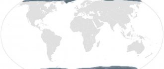
Parts of the world include:
- Antarctica;
- America (both, without division);
- Africa;
- Asia;
- Australia;
- Europe.
A continent is a large piece of land washed by the ocean. When dividing into continents, only geological factors are taken into account, but there are different continental models.
Some propose to distinguish 7 continents:
- Africa;
- Europe;
- Asia;
- North America;
- South America;
- Australia;
- Antarctica.
Others divide only into 4 continents - Afro-Eurasia, America, Australia, Antarctica.
But the most common option is 6 continents:
- Eurasia;
- Africa;
- Australia;
- Antarctica;
- North America;
- South America.
Parts of the world and continents, differences.
Unlike the model with 7 continents, this option takes into account the fact that Europe and Asia are on the same common land mass, Africa is separated from Eurasia by a thin isthmus (interrupted by the Suez Canal), and the Americas are also separated by a thin isthmus with a canal.
Continental models
There are several traditions in the world of dividing lands into continents and parts of the world.
| Number of continents in different traditions | ||||||||
| The colors highlight parts of the land that are classified into continents in various cultures. | ||||||||
| 4 continents[5] | Afro-Eurasia | America | Antarctica | Australia | ||||
| 5 continents [6][7] | Africa | Eurasia | America | Antarctica | Australia | |||
| 6 continents[8] | Africa | Europe | Asia | America | Antarctica | Australia | ||
| 6 continents [9] | Africa | Eurasia | North America | South America | Antarctica | Australia | ||
| 7 continents [10][11][12][13][14][15] | Africa | Europe | Asia | North America | South America | Antarctica | Australia | |
- The seven continents model is popular in China, India, partly in Western Europe and in English-speaking countries.
- The six continents model with a united America (“Parts of the World”) is popular in Spanish-speaking countries[ and parts of eastern Europe, including Greece with its pentacontinental model (five inhabited continents).
Comparison of area and population
| Continent | Length (km from east to west, and from south to north, along the periphery) | Sushi share | Population | Population share | Population density |
| Afro-Eurasia | 1644,9×822,45. | 58 %. | 71 %. | 95. | |
| America | 833.2x416.6. | 29 %. | 12 %. | 22,1. | |
| Oceania | 491.2x245.6 | 8 %. | 8 % | 3.2 |
Eurasia
Eurasia on the globe
Eurasia is the largest continent on Earth, and the only one washed by four oceans: in the south - Indian, in the north - Arctic, in the west - Atlantic, in the east - Pacific. The continent is located in the Northern Hemisphere between 9° W. Longitude and 169°W etc., while some of the islands of Eurasia are located in the Southern Hemisphere. Most of continental Eurasia lies in the Eastern Hemisphere, although the extreme western and eastern ends of the continent are in the Western Hemisphere. Eurasia stretches from west to east for 10.5 thousand km, from north to south - for 5.3 thousand km, with an area of 53.6 million km². This is more than a third of the entire land area of the planet. The area of the Eurasian islands is approaching 2.75 million km².
Contains two parts of the world: Europe and Asia. The border line between Europe and Asia is most often drawn along the eastern slopes of the Ural Mountains, the Ural River, the Emba River, the northwestern coast of the Caspian Sea, the Kuma River, the Kuma-Manych depression, the Manych River, the eastern coast of the Black Sea, the southern coast of the Black Sea, the strait Bosphorus, Sea of Marmara, Dardanelles, Aegean and Mediterranean Seas, Strait of Gibraltar. This division has developed historically. Naturally, there is no sharp border between Europe and Asia. The continent is united by the continuity of land, the current tectonic consolidation and the unity of numerous climatic processes.
North America
North America on the globe
North America (English North America, French Amérique du Nord, Spanish América del Norte, Norteamérica, Asian Ixachitlān Mictlāmpa) is one of the continents of planet Earth, located in the north of the Western Hemisphere of the Earth. North America is washed from the west by the Pacific Ocean with the Bering Sea, the Gulf of Alaska and the Gulf of California, from the east by the Atlantic Ocean with the seas of Labrador, the Caribbean, Gulf of St. Lawrence and Mexico, from the north by the Arctic Ocean with the Beaufort, Baffin, Greenland and Hudson Bay seas. From the west, the continent is separated from Eurasia by the Bering Strait. In the south, the border between North and South America passes through the Isthmus of Panama.
North America also includes numerous islands: Greenland, the Canadian Arctic Archipelago, the Aleutian Islands, Vancouver Island, the Alexandra Archipelago and others. The area of North America including the islands is 24.25 million km², without the islands it is 20.36 million km².
South America
South America on the globe
South America (Spanish: América del Sur, Sudamérica, Suramérica, port: América do Sul, English: South America, Dutch: Zuid-Amerika, French: Amérique du Sud, Guar: Ñembyamérika, Quechua: Urin Awya Yala, Urin Amerika) - southern a continent in America, located mainly in the Western and Southern hemispheres of planet Earth, however, part of the continent is also located in the Northern Hemisphere. It is washed in the west by the Pacific Ocean, in the east by the Atlantic Ocean, in the north it is limited by North America, the border between the Americas runs along the Isthmus of Panama and the Caribbean Sea.
South America also includes various islands, most of which belong to the countries of the continent. The Caribbean territories belong to North America. The South American countries that border the Caribbean Sea—including Colombia, Venezuela, Guyana, Suriname, and French Guiana—are known as Caribbean South America.
The most important river systems in South America are the Amazon, Orinoco and Parana, whose total basin is 7 million km² (the area of South America is 17.8 million km²). Most of South America's lakes are in the Andes, the largest of which and the world's highest navigable lake is Titicaca, on the border of Bolivia and Peru. The largest lake in area is Lake Maracaibo in Venezuela; it is also one of the oldest on the planet.
The tallest waterfall in the world, Angel Falls, is located in South America. The most powerful waterfall, Iguazu, is also located on the mainland.
The continent's area is 17.8 million km²: 4th place among the continents.
Africa
Africa on the globe
Africa is the second largest continent after Eurasia, washed by the Mediterranean Sea from the north, the Red Sea from the northeast, the Atlantic Ocean from the west and the Indian Ocean from the east and south. Africa is also the name given to the part of the world consisting of the continent of Africa and adjacent islands.
The African continent crosses the equator and several climate zones; it is the only continent that stretches from the northern subtropical climate zone to the southern subtropical one. Due to the lack of constant precipitation and irrigation - as well as glaciers or the aquifer of mountain systems - there is practically no natural regulation of climate anywhere except the coasts.
Australia
Australia on the globe
Australia (from the Latin australis - “southern”) is a continent located in the Eastern and Southern Hemispheres of the Earth. The entire territory of the mainland is the main part of the state of the Commonwealth of Australia. The continent is part of the world Australia and Oceania. The northern and eastern coasts of Australia are washed by the Pacific Ocean: the Arafura, Coral, Tasman, Timor Seas; western and southern - Indian Ocean. Near Australia are the large islands of New Guinea and Tasmania. Along the northeastern coast of Australia, the world's largest coral reef, the Great Barrier Reef, stretches for more than 2000 km[17].
Antarctica
Antarctica on the globe
Antarctica (Greek ἀνταρκτικός - the opposite of Arctida) is a continent located in the very south of the Earth, the center of Antarctica approximately coincides with the southern geographic pole. Antarctica is washed by the waters of the Southern Ocean. Antarctica is also called the part of the world consisting of the mainland of Antarctica and adjacent islands.
Antarctica is the highest continent, its average height is 2040 meters. The continent also contains about 85% of the planet's glaciers. There is no permanent population in Antarctica, but there are more than 50 scientific stations belonging to different states and intended for research and detailed study of the features of the continent.
Antarctica is almost completely covered by ice sheets, the average thickness of which exceeds 2,500 meters. There are also a large number of subglacial lakes (more than 140), the largest of which is Lake Vostok, discovered by Russian scientists in the 1990s.
Europe
Parts of the world (names) and continents have similarities. So, on the continent of Eurasia, in the west, southwest, there is Europe. As a part of the world, Europe is limited from the east by the Ural Mountains, the Embe River (to the Caspian Sea), and from the west by the Atlantic Ocean.
The southern border runs along the seas:
- Mediterranean;
- Black;
- Marble;
- Aegean.
In the north, part of the world is limited by the Arctic Ocean. The area of this part of the world is 10,180,000 square meters. km. The climate in most of the territory is temperate, but closer to the northern borders it changes to continental, subarctic and arctic. Near the southern borders the climate is Mediterranean and semi-desert. Most of western Europe has an oceanic climate.
This part of the world includes almost all natural areas. There are 2 types of tundra, and 2 types of steppes, mountain, Mediterranean and deciduous forests, taiga.
The highest point in Europe is Mont Blanc (4808 m), the lowest is the Caspian Sea, -27 m. The largest lakes are Ladoga, Chudskoye and Onega.
The main geographical feature is the large number of peninsular inhabited territories and islands, including those located far from the mainland (for example, Iceland). The most unique animal that lives only in Europe and is listed in the Red Book of Russia is the muskrat. There is only 1 subspecies - the Pyrenean muskrat. There are external differences between them, but the lifestyle differs slightly.
One of the endemic plants is Hyacinth Pallas. In the wild, the flower is found in the Rostov region of Russia and Ukraine. It blooms with blue flowers collected in racemes. Another endemic is Ulex Gallia, a low-growing shrub with medium-sized yellow flowers, belonging to the legume family.
Among the geographical features, the Icelandic waterfall Gljufrafoss, which flows into a cave, is of particular interest. To appreciate the uniqueness of the object, you need not only to look at the waterfall from afar, but also to get into the cave. It seems as if the water is falling out of nowhere.
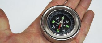
What do the letters on a compass mean?
A compass is needed for orientation on the ground (anywhere: on land, water, and so on). It helps you choose the desired direction of movement due to the fact that you can determine the location of the cardinal points on it. The compass is only useless in anomalous areas and near a large magnet.
The most common ones now are compasses with English letters:
- N (north) is north;
- E (east) is east;
- W (west) is west;
- S (south) is south.
On compasses with Russian letters, everything is obvious; you just take the first letters from each side of the world (N, E, S, Z).
Zummy
To navigate with a compass, you need to look where the compass needle is pointing.
The one end with the arrow, or the blue end, of the magnetic needle of the compass always points north.
On some compasses, the cardinal directions are indicated in Russian letters:
On most compasses, the cardinal directions are indicated in English letters, according to the English names of the cardinal directions:
In maritime navigation there are compasses with cardinal directions marked in German letters:
On some compasses, in addition to the main cardinal directions, intermediate ones are indicated, an example for Russian letters:
Lyudmila1979
A compass is a very useful and irreplaceable device, which you simply cannot do without in the forest or anywhere else. A compass is designed to show us the cardinal directions.
The simplest compasses have 4 Latin letters: N – north (north), S – south (south), E – east (east), W – west (west).
But sometimes the compass still has northeast (NE), southeast (SE), southwest (SW) and northwest (NW) indicators. (see photo below)
Syshka
On the compass, the letters indicate the beginning of the words of the cardinal directions. N – north – north, S – sorth – south, E – east – east, W – west – west. Well, accordingly, the Russian compass has exactly the same designations. North South West East.
Shipo3
The compass is a useful device that can work without batteries that need to be charged. This means the device will be able to work for a long time without interruption. However, you need to know how to use it. For example, the letters S, N, C, W, E are written on the compass dial. They mean cardinal directions: S or Y means south, N or “C” means north, W is west, E means east.
This is interesting: How to protect yourself from a household gas explosion: simple rules and tips
Dmitry68
The part of the compass on which the four Latin letters N, S, W, E are depicted is called the limb. This is how the cardinal directions are indicated by the first characters of the corresponding words:
- N – North (north);
- S – South (south);
- W – West (west);
- E – East (east).
On old Soviet-style models, the cardinal directions were designated by letters of the Russian alphabet: S, Yu, Z, V.
The designation is applied evenly, dividing the full circle into 90-degree sectors.
Alexgroovy
The letters on the compass indicate the cardinal directions.
The starting point is considered to be the letter _С_, which means north.
Then clockwise at equal intervals go:
There are also compasses on which the cardinal directions are indicated in English letters:
Asia
Parts of the world (names) and continents that sound similar have not bypassed Asia; it is located on the same continent as Europe, but to the east of the Ural Mountains. There is also a border between Africa and Asia - the Suez Canal. It is interesting that in ancient times the border passed along the famous African Nile River.
Asia is washed by the Arctic and Indian oceans and seas belonging to the inland waters of the Atlantic Ocean - Azov, Marmara, Black, Mediterranean, Aegean. The area of the world is 43,475 thousand square meters. km.
The highest point in Asia is 8848 m, Mount Everest (Qomolungma), the lowest point is the Dead Sea, -407 m.
All climatic zones are found in Asia - arctic (Siberia), equatorial, monsoon, continental, semi-desert and desert, tropical.
The main geographical feature is the highest mountains (Himalayas) and plateaus in the world, the Tibet plateaus. Unique bulls and yaks are also bred here, and wild animals are also found. Domestic animals are used as beasts of burden; meat and milk are also consumed as food.
A unique but well-known plant is ginseng. All varieties except spotted ginseng grow wild exclusively in Asia. The plant has been known as a medicinal plant since ancient times, and is now used as a tonic and adaptogen.
Of interest is such a natural attraction as the volcanoes of the Kamchatka Peninsula. This is a UNESCO World Heritage Site, which includes about 30 active and 300 extinct volcanoes.
It is also noteworthy that they are located in different parts of the peninsula and in different specially protected natural parks, but are considered one object. It is interesting that the exact number of volcanoes in Kamchatka cannot be calculated and different sources indicate different numbers - from 3-4 hundred (both active and dormant) to more than a thousand.
Don’t miss the most popular article in the section: Where the Yenisei River flows, source, mouth, description, where it is located.
Africa
Parts of the world (names) and continents that coincide geographically completely or partially are a common phenomenon and Africa is one of them. This includes the entire territory of the mainland of the same name east of the Suez Canal and adjacent islands such as Madagascar and St. Helena. Mount Kilimanjaro is the highest point in Africa - 5895 m, the lowest point is Lake Assal, -157 m.
Africa is washed by the Atlantic and Indian Oceans, as well as the Mediterranean and Red Seas. Territory – 30221532 sq. km. It is interesting that the equator line runs almost through the center of the continent, but due to the specific climate, the natural zones are not mirrored on both sides. Nevertheless, all climatic zones ranging from northern subtropical to southern are present on the mainland.
Despite the fact that the Sahara Desert is most often associated with that part of the world, Africa has vast wet areas. They are located in the central part of the mainland and on the coast of the Gulf of Guinea, where all African forests are concentrated.
In the Namib Desert, a plant has been preserved that cannot be found anywhere else - amazing Velvichia. It can grow up to 1000 years, growing only 2 leaves in its entire life. However, the leaves can be longer than 3 meters and grow very slowly. Interestingly, the plant is so unique that it is depicted on the national emblem of the country of Namibia.
In Africa, the only representative of the okapi genus lives - Johnston's okapi. It is a short, cloven-hoofed herbivore, similar to a hybrid of a horse and a giraffe, but with stripes on its legs.
Of the geographical features, the most famous and visited is Victoria Falls on the Zambezi River. This is the only waterfall that is more than a kilometer wide (1800 m). It is higher than Niagara Falls, and the “fog” formed from the falling water sometimes rises above 400 m.
North America
The part of the world and the continent with this name is located in the northern part of the Western Hemisphere of the Earth.
North America is washed by oceans:
- Arctic.
- Atlantic.
- Quiet.
In the south it is washed by the waters of the Gulf of Mexico. The area of the world is 24,365,000 square meters. km. North America in its northern part is similar to similar latitudes in Eurasia. The only difference is that the north of the continent comes closer to the North Pole, at the expense of Greenland and the Canadian archipelago. North America lacks only an equatorial climate zone.
The north is occupied by tundra and arctic deserts. Most of the western territory of North America is occupied by mountains, and only on the coast the situation changes and the north and south coasts are divided into taiga and Mediterranean climate zones. The eastern part is more diverse.
The tundra is replaced by a taiga climate, then a zone of mixed and variable-humid forests in the east, and next to the mountains there is only a zone of steppes or forest-steppes.
Due to the dense population of the continent, wildlife can be found either in uninhabitable areas or in nature reserves. Thus, one of the examples of wildlife is located in Yellowstone National Park. It has nature and fauna typical of the middle zone, complemented by bison, snow goats, and wolverines. There is also information about the habitat of turtles in the park.
In the northwest of Yellowstone, 2000 mm of precipitation per year will fall, which is not typical for this natural area. Interestingly, the park is located inside a huge caldera of a dormant ancient volcano. This partly explains the area's microclimate and winter precipitation.
One of the unique plants not found in other parts of the world is the Florida yew. This is a shrub, rarely a tree, no higher than 10 m in height, trunk diameter does not exceed 40 cm. The species is on the verge of destruction. Unique cacti of the genus Mamillaria grow in Mexico.
A specific endemic animal is the water rabbit. It differs from the ordinary one in its small ears and way of life. The animal settles near bodies of water and is able to swim across medium-sized bodies of water. To hide from predators, the rabbit completely hides under water, leaving only its nose outside to breathe.
[edit] Geography
Vanuatu Islands Map
The Republic of Vanuatu is a chain of 83 Y-shaped islands stretching 1,176 km from north to south. The closest country is the Solomon Islands, located 170 km north of Vanuatu.
The land area is 12,336 km2. There are 14 large and 60 small islands in the archipelago. The most important of them are the islands of Efate, Espiritu Santo, Tanna and Malekula. The largest island is Espiritu Santo, on which the highest point of the country is located - Mount Tabwemasana with a height of 1879 m. Most of the islands have a mountainous terrain. Some islands have steep cliffs and are surrounded by coral reefs.
From a geological point of view
The islands of Vanuatu are quite young. They were formed as a result of four stages of volcanic activity, which was caused by the movement of lithospheric plates in this region. The Republic of Vanuatu is located at the junction of the Australian and Pacific lithospheric plates, which causes frequent volcanic eruptions. The most famous active volcano is Yasur on the island of Tanna with a height of 365 m. Not far from it lies Lake Sivi, surrounded by volcanic ash and lava valleys. There are underground caves on the islands, the most famous of which is Siviri on the island of Efate.
The Republic of Vanuatu is poor in mineral resources
. There are minor deposits of gold (Espiritu Santo Island) and manganese (Efate Island).
Stream on Efate Island
Climate of Vanuatu
- humid tropical, close to equatorial. On some islands, the climate varies depending on the altitude. At low altitudes there is an equatorial climate with 2500–4000 mm of precipitation per year. At an altitude of 200–600 m, the amount of precipitation exceeds 5000 mm. From May to October the islands are exposed to south-easterly breezes, resulting in sunny weather and cool nights. From November to April there are heavy rainfalls and high temperatures. In the northern islands, during the rainy season the average temperature reaches 30°C, and during the dry season - about 20°C. On the southern islands, the average temperature ranges from 17 to 29°C.
Kauri tree ( Agathis australis
) - a valuable type of wood
For soils of the Republic of Vanuatu
characterized by a high content of volcanic ash. There are 3 types of soils on the islands: ferralite soils in the southeastern islands, fersiallite soils in the northwestern islands, and andic soils in the highlands. Rivers in Vanuatu are few in number, and on some islands they are completely absent.
Formation of local flora and fauna
began after the end of major geological processes in the New Hebrides. Most plant and animal species originate from Indo-Australasia. Vanuatu has several vegetation zones: valley forests, montane forests, seasonal forests, new volcanic surface vegetation, riparian vegetation and secondary vegetation. At an altitude of more than 500 m above sea level, agathis, footcarp, metrosideros, syzygium, weimania and other plant genera grow. The coastal region is characterized by mangrove forests, casuarinas, pandanas, barringtonias, and haritakis. The total number of vascular plants is about 870 species, of which 130 are endemic. Bananas, yams, taro, cycads, maize, breadfruit, and sugar cane have been introduced.
Mammals on the islands are represented by 4 species of flying foxes and 8 species of bats (4 of them are endemic). Vanuatu is home to 57 species of birds (7 endemics), 17 species of reptiles, 12 species of ants and termites, 71 species of butterflies, 76 species of snails (57 endemics). Sea turtles lay eggs in coastal waters, and sharks are found near the islands of Ambae, Ambrym, Paama, Pentecost and Malekula. Pigs, dogs and poultry were introduced.
Best articles: Veterinary passport for a cat - how to obtain and fill out correctly
protected areas in the Republic of Vanuatu
, covering 427 km2 of land (3.44%) and 148 km2 of sea (0.02%). 5 territories have an IUCN category: 1 belongs to category III (natural monument) and 4 to category VI (sites of sustainable environmental management).
South America
A part of the world that only partially coincides with the mainland in name and is symbolically divided with its other half - South America. It is located in the Southern Hemisphere, in the west, only a small part is located in the Northern Hemisphere. South America is washed by the Pacific and Atlantic oceans and the Caribbean Sea.
The Isthmus of Panama between the Americas simultaneously connects continents and separates parts of the world, especially after the advent of the Panama Canal. Part of the world covers an area of 17,840,000 square meters. km.
This part of the world has 5 types of climate - tropical, subtropical, temperate, equatorial and subequatorial. Therefore, despite one of the harshest deserts, the Atacama, South America is the wettest part of the world.
One of the features is the most extensive rainforests in the world, in the Amazonian lowlands, around the Amazon River.
It is noteworthy that the entire territory of the jungle has not yet been fully explored. On the other hand, the Andes mountains separate a small strip of desert in the west of the continent from the rest of the territory, which is humid and relatively warm. It is noteworthy that the southernmost part of the world differs little in climate from the climate of central Russia. So, in Argentina exactly the same birch and pine trees grow.
You can understand that this is South America only by the parrots sitting on unremarkable trees. Of interest is the unique Angel Falls, 979 m high. It is believed that this is the highest waterfall in the world. Another name for the object is Kerepakupai-meru.
A unique representative of the local vegetation is the Roraima sundew. This insectivorous plant grows in the Guiana Highlands, in swampy, wet places. Sundew blooms with small white flowers. The plant is crimson-red in color, the leaves are collected in a rosette, covered with hairs that secrete a special sticky liquid necessary to catch insects and digest them.
A representative of the animal world not found in other parts of the world is the Mountain Tapir. They are found only in some parts of the Andes in Ecuador, northern Peru, and Colombia. The species is considered endangered.
What are the oceans?
The science of oceanology deals with the study of hydrological processes. The waters of individual water areas have distinctive characteristics and their own unique flora and fauna. Borders are determined by currents and the location of continents.
Quiet (178.68 million km2)
The largest in area and volume of water in the world, it accounts for 53% of the water volume of the entire World Ocean. Otherwise called the Great. If you calculate the land surface area, the Pacific waters will exceed it by 30 million square kilometers - it is so huge.
Pacific Ocean area
The name of the space was given by Ferdinand Magellan, who crossed it and never encountered a storm along the way. The borders are drawn up along the shores of Australia, Eurasia, North and South America. In addition to its size, it is famous for its depth. Here is the Mariana Trench, the deepest trench in the world (11,022 meters).
High salinity is observed in the tropical zone, it decreases with decreasing temperature. Ice in this area is found only in the Antarctic and Arctic zones.
Sand sharks off the coast of Australia in the Pacific Ocean pose a danger to humans
Atlantic (91.66 million km2)
It ranks second in area and depth. From the east it is limited by the shores of Africa and Europe, from the west – by South and North America. The deepest point was recorded at 8,742 meters in the Puerto Rico Trench.
Atlantic Ocean area
The seas and bays of the water area are clearly defined, outlined by groups of islands and an indented coastline. Named after the titan from ancient Greek mythology. The Atlantic Ocean has a large meridian extent and free circulation with the pole zones, which affects the system of prevailing winds.
A special feature is the slight annual fluctuations in water temperature. In temperate latitudes the average change does not exceed 8 degrees. The saltiest zone is the Mediterranean Sea. Due to the increase in fishing and mammals, whales, turtles and other representatives of the living world are under threat of extinction.
A view from space of Atlantic Hurricane Irma, which caused tens of billions of dollars in destruction.
Indian (76.174 million km2)
Between the African, Eurasian and Australian continents is the third largest ocean by area. Named in honor of India, which in ancient times was a country to which sailors were looking for a route. Three sectors make up the bottom:
- Antarctic;
- African;
- Indo-Australian.
Indian Ocean on the map
The connecting ridges in the western part are of volcanic origin and seismic activity. Is the most salty. In the Red Sea area this figure reaches 41 ppm.
It is noteworthy that fishing here is underdeveloped. The extraction of pearls and mother-of-pearl, as well as hydrocarbon raw materials, is carried out. Tourism is developed in this zone, in which countries such as Malaysia, Thailand, and Egypt have succeeded.
The basis of the economy of the Seychelles, located in the Indian Ocean, is tourism (70% of budget foreign exchange income)
Yuzhny (20.327 million km2)
A relatively new concept, this ocean began to appear on world maps at the end of the 20th century. Moreover, it was first mentioned three centuries ago. It does not have geographically designated boundaries, that is, it is not isolated by groups of islands or the shores of continents. It is believed that its isolation is necessary because there is an invisible line of intersection of warm and cold currents.
Antarctica and the Southern Ocean washing its shores
From the Arctic Circle to 40 degrees south latitude you can experience some of the gustiest winds on the planet. At some points they are constant and so strong that they rid the coastline of ice. The climate is harsh. Numerous seas freeze here, and in summer the ice breaks off and wanders in the waters. They pose a hazard to shipping. The largest ones reach a length of 180 and a width of tens of kilometers.
Bust of Lenin at the Pole of Inaccessibility, the closest Soviet station to the South Pole (now closed)
The Southern Ocean is not the smallest ocean on Earth. Despite the cold climate, it is full of life. The water area is home to plankton, blue whales, fur seals and leopards, and seals.
Best articles: Ragamuffin - a pet “bear cub” with an angelic disposition
Australia
Parts of the world (names) and continents that coincide almost completely include Australia. It is located in the southern hemisphere of the planet, among the Pacific and Indian Oceans.
It is also washed by the seas:
- Timorese;
- Coral;
- Tasmanovo.
Australia includes New Guinea, Tasmania, Solomon Islands, and New Zealand. Area – 8510000 sq. km.
Australia is the most deserted part of the world. The continent, after which the part of the world is named, consists almost entirely of various deserts, only on the coast the situation changes. Only due to the islands and the mainland coast, Australia has a temperate, subtropical, humid and equatorial climate. Another interesting feature is that most of Australia's rivers dry up.
Australia and Oceania are rich in endemic species of animals and birds. One of the birds that is little known, unlike the kiwi, the ostrich or animals such as the kangaroo or the Tasmanian devil, is the kakapo parrot. The bird is on the verge of extinction and is considered the oldest bird species living today. The peculiarity of kakapo is that they do not fly and lead an evening and nocturnal lifestyle.
The only available way to fly is to climb a tree with your claws and glide.
Wild eucalyptus is a tree not found anywhere except Australia and Oceania. Cultivation is possible in any favorable conditions and is widespread for the extraction of essential oil and for decorative purposes. The only exception is the rainbow eucalyptus, which grows in the Northern Hemisphere.
The most famous and interesting geographical feature is Mount Aires Rock or Uluru. It is about 6 million years old; there are many drawings of ancient aborigines on the surface. Moreover, the indigenous population considered Uluru a sacred place.
History of the discovery of continents
The very first boundaries between continents began to be drawn by ancient Greek sailors. They gave the names Europe and Asia to the territories that lie on either side of the shipping routes of the Aegean Sea, the Dardanelles Strait, the Sea of Marmara, the Bosporus Strait and the Black Sea.
The names were at first applied only to the immediate coasts and only much later expanded to include inland areas. At the same time, the border cannot be called complete, since sailors could only draw it to the end of the shipping routes, and ancient Greek geographers were unable to draw a border between Eurasia, since no convincing landscape element was discovered for division.
Interesting facts: North America is the only continent that has all types of climates - tropical, dry, continental, temperate and polar. North America was named after the explorer Amerigo Vespucci. North America has the highest average income per person compared to any other continent, and average food consumption per person is also higher than other continents.
The ancient Greeks also wondered whether Africa (then called Libya) should be considered an extension of Asia or another part of the world. The idea of an Africa separate from Asia won the debate. Thus the world became tri-continental.
Christopher Columbus sailed from European ports across the Atlantic Ocean in 1492, heading to Asia, but he came ashore in the West Indies. Thus began the long journey of European exploration of two new continents - North and South America. But it is worth noting that Columbus did not fully believe that he had discovered new lands; for him it was only Asia.
The voyage routes of Christopher Columbus Interesting facts: The largest reserve of ice is located on the territory of Antarctica - as much as 75%. It is estimated that the ice thickness reaches 4 km! Antarctica also contains about 70% of the world's fresh water.
But already in 1501, Amerigo Vespucci and Gonzalo Coelho decided to conduct an expedition and go around the southern tip of Asia to reach the Indian Ocean, passing through the Fernando de Noronha archipelago. But on the way they came across Brazil, and along its shores they made a grand journey to the south.
They then realized that Asia could not extend that far, so upon arriving in Europe, Vespucci published a report called Mundus Novus (New World). In it, he wrote: “I was able to find a continent in the southern regions, where there are more people and animals than in Europe, Asia or Africa,” this is the first recorded evidence of America acquiring the status of a continent.
Interesting facts: Asia is the largest continent on Earth, occupying a third of the earth's surface. The world's largest cave is located in Asia. Most of the world's religions originated in Asia.
At the end of the 18th century, a gradual division of North and South America began in the scientific world - thus, from that moment on, the model of 5 continents appeared. This view was not particularly popular among geographers, so the 4 continents model prevailed for most of the 19th century.
Interesting facts: Europe is the only continent without deserts. Germany is the most populous country in Europe, and London and Paris are the most populous cities in Europe. Both world wars mainly took place in Europe.
Europeans discovered Australia in 1606, but for some time they considered it part of Asia. By the end of the 18th century, some geographers began to call it an independent continent, which made it the sixth (the model was not popular).
Sailors from Europe first set foot on the coast of Australia back in 1606; the erroneous assumption was made that these were the southern territories of Asia. Only at the end of the next century did geographers begin to call it an independent continent. This is how the 6 continents model appeared (the model was not popular).
Best articles: TOP 10 interesting and surprising facts about stick insects
Interesting facts: Australia is the largest island in the world, but it is also the smallest continent. There is only one country in Australia - Australia itself.
As a result of the First Russian Antarctic Expedition, Antarctica was discovered. After this there was a US expedition led by Charles Wilkes, who in 1838 awarded the title of continent to the frosty shores. True, his zeal was not shared by scientists. For almost 100 years it did not have the status of a part of the world. Most of the world's scientists did not consider it a continent until the end of World War II.
Antarctica
The continent and part of the world Antarctica are located in the very south of the planet, the center of the continent approximately coincides with the South Pole. Area - 14107000 sq. km.
| Washing oceans | Atlantic, Pacific, Indian. |
| Characteristic plants | Clobanthus Quito, Antarctic meadow, various mushrooms, lichens, mosses, algae. |
| Unique animals | The Emperor Penguin is the heaviest and largest penguin species in existence. |
| Specific geographical feature | Volcano Erebus. Its peculiarity is an eruption without lava or ash. Erebus emits exclusively crystalline forms. The crater contains a unique lava lake. |
| Geographical features | The part of the world that is maximally covered with ice. |
Part of the world is mostly a glacier, sometimes breaking off at the edges and forming icebergs. The glacier is pierced by mountain peaks - the maximum height is 4892 m. The direction of the winds is from the center of Antarctica to the ocean. Most plants appear on the Antarctic Peninsula in summer.
Antarctica is characterized by a polar day and a polar night, when you can see the aurora. But this phenomenon is more impressive on the opposite side of the globe.
The names of parts of the world and continents are known to everyone. However, they say nothing about the characteristics of the continents. Most often, the names developed historically or were given in honor of the discoverers. However, it is important to distinguish between continents and parts of the world.
Article design: Oleg Lozinsky