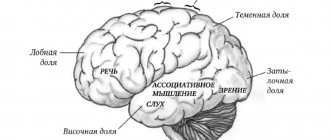
Terrain and its tactical properties. Topographical elements of the area.
Terrain is a part of the earth's surface. The totality of its unevenness is called relief, and all the objects located on it, created by nature and human labor (rivers, forests, settlements, etc.), are local objects. Local objects that occupy vast territories (inland seas, mountain systems, deserts, etc.) are usually called geographical objects.
Based on the homogeneity of their economic and military significance, local objects are divided into groups called topographical elements of the area. The main topographical elements of the area are relief, hydrography, vegetation cover, soils, road network, settlements, industrial, agricultural and socio-cultural objects.
Topographical elements of the area are interconnected. Thus, the relief significantly influences the configuration of roads, the layout of settlements, the distribution of soils and vegetation; soils largely determine the nature of vegetation and the depth of groundwater.
In various combinations and in conjunction with climate, topographic elements form a wide variety of terrain types. Each type of terrain has its own characteristics, which have a positive or negative impact on various aspects of military operations of troops: operational formation (building battle formations) in the offensive and defensive, the use of military equipment, the speed of the march and the pace of the offensive, the organization of the protection of troops from modern means defeats.
Type of terrain as a landscape complex and its significance for the geographical knowledge of the country
Terrain type, like landscape or region, is one of the most common and important concepts in landscape (complex physical) geography. V.P. Semenov-Tyan-Shansky wrote back in 1928 that “...the search for types of localities is the first, most important, essential, integral feature of geographical science...” (p. 48). Researchers showed particular interest in this concept in the post-war years, during the period of widespread theoretical and field landscape work. Despite the widespread, if not universal, recognition of terrain types as landscape complexes, until recently different researchers have not put the same content into this concept. In this article we make an attempt to clarify the concept of “terrain type” and find out its place and significance in landscape geography.
A brief overview of existing views in the literature on the scope and content of the concept “type of terrain”
In special geographical literature, the term “type of locality” or similar “typical localities”, “types of localities” began to be used from the middle of the 19th century. Tracing the literature published since that time, it is not difficult to identify three different points of view on the scope and content of the concept of “terrain type”. According to the first of them, the type of terrain is a regional physical-geographical unit. One of the first to express this point of view was P. P. Semenov-Tyan-Shansky .
In Western Siberia, he distinguished the Tobol-Ishim, Barabinsk, Tobolsk, Tomsk, Altai, Upper Irtysh and Lower Ob “typical localities” (Semyonov, 1884). As N.I. Mikhailov correctly notes, “typical localities” in this case are essentially synthetic geographical areas of regional zoning...” (Mikhailov, 1955, p. 122). V.P. Semenov-Tyan-Shansky in the well-known work “Types of localities in European Russia and the Caucasus” (1915) by “types of localities” meant regional units close to physical-geographical provinces in the modern concept.. Thus, into independent “types ; localities,” he singled out the Polesie subglacial water accumulation, the Donetsk ridge, the Volga loose ravine region, the Zhiguli or Samara Luka, the Trans-Volga lowland and others. B. L. Bernstein divided the territory of the Yaroslavl province into “physical-geographical areas,” which he considered synonymous with physical-geographical regions.
According to the second point of view, until recently the most widespread, locality type is a general typological concept. While putting broad typological content into this term, researchers did not limit its use to any taxonomic framework.
Over 100 years ago, N.A. Severtsov identified “clans of localities” on the territory of the former Voronezh province, symmetrically located along the rivers. In particular, he named the following types of areas: low sand spits; sandy-silty sediments with alder, meadows and lakes; steep edge of the valley with marginal forest, yarugi or treeless; a strip of villages; a strip of cultivated fields with fallow lands; steppe (Severtsov, 1950).
A. N. Krasnov in 1886 used the term “type of terrain” when describing the right bank of the Volga and Oka in the former Nizhny Novgorod province. He named 19 types of terrain, which in their volume are close to the types of tracts in the modern concept (exposed steep clayey slopes, bottoms of shady flooded ravines, etc.). In the same period, P.P. Semenov describes the types of localities of Central Asian deserts, highlighting the loess foothills watered by ditches; short transverse valleys of the Kopet-Dag with their irrigated rivers; bare and waterless slopes and peaks of Kopet-Dag; coastal steppe flow of a large Central Asian river; a cultural oasis remote from the mountains; sandy desert near the Repetek station.
G. N. Vysotsky also uses the term “type of locality” in a general typological sense. Thus, he calls the eastern slopes of Ergeni, characterized by rugged terrain and frequent changes in soil and plant groups, a “variegated type of terrain,” while the Caspian semi-desert is an example of a monotonous territorial type (Vysotsky, 1904).
During the Soviet period, the term “terrain type” as a general, non-taxonomic concept became widespread in the works of employees of the Institute of Geography of the USSR Academy of Sciences. In the 40s, a special group was created to compile complex physical and geographical maps. In addition to the institute’s staff, representatives of the Soil* and Botanical Institutes took part in its work. Of the three maps compiled by this group, two are landscape-typological in nature. The main objects depicted on them are the terrain types of the European part and the eastern regions of the country. These researchers do not give a detailed definition of the type of terrain highlighted on the maps; it is only known that each type of terrain is characterized by “a specific and similar combination of physical-geographical conditions” (Gerasimov and Kes, 1948, p. 352). As special types of terrain, such natural complexes as loaches, taiga plateaus, mountain-hill taiga, taiga small mountains, taiga-ridge plains, steppe small hills, steppe plains, elevated tundra, low-lying swampy tundra, salt marshes, takyrs, deserts are identified as special types of terrain. sandy hilly and dune plains, etc.
The ideas underlying these maps of terrain types were further developed in the works of V. S. Preobrazhensky, N. V. Fadeeva and L. I. Mukhina (Preobrazhensky and Fadeeva, 1955; Preobrazhensky, 1957; Preobrazhensky et al. 1959 ; Preobrazhensky, Fadeeva, Mukhina, 1961; Types of terrain and natural zoning of the Chita region, 1961; Fadeeva, 1961). These authors, relying on the statements of G.N. Vysotsky (1904, 1909) about phytotopological maps, or maps of habitat types, did a lot of work to identify and map terrain types in the Buryat Autonomous Soviet Socialist Republic and the Chita region.
V. S. Preobrazhensky proposes to consider as a type of terrain “those areas of territory that have a complex of natural conditions necessary (or unsuitable) for the growth of a certain set of agricultural crops” (Preobrazhensky, Fadeeva, Mukhina, Tomilov, 1959, p. 42). As independent types of terrain, he and his collaborators distinguish the following natural complexes: in the Buryat Autonomous Soviet Socialist Republic - mountain dry steppe, mountain steppe, forest-steppe and mountain forest-steppe, mountain taiga, pre-alpine open forest, char, meadow flat riverine plains, meadow gently sloping plains, birch forests, pine forests. forests, mountain tundra (ibid.); in the Chita region - dry steppe, steppe, forest-steppe, taiga, pre-goltsy open forest, char, meadow plains, birch forests, goosefoot, pine forests (Types of terrain and natural zoning of the Chita region, 1961).
It is easy to see that V. S. Preobrazhensky and his colleagues distinguish landscape complexes that are far from equivalent as types of terrain: steppe, forest-steppe, taiga, i.e. zonal complexes (types of landscape, in the opinion of most researchers) are placed on a par with meadow flat riverine plains, birch forests, pigweeds and pine forests, found in separate fragments in zonal complexes.
Essentially synonymous with the type of terrain as a general typological concept are many of the geographical landscapes of L. S. Berg (1947) (spruce forests of the lowland forest zone, ravine landscape of the forest-steppe, sands of the desert zone, river valleys of the desert zone, etc.), landscapes in the works of B B. Polynova (1926, 1927), types of territory in the works of A. N. Ponomarev (1937) and Z. M. Murzaev (1953), landscape and type of landscape in the view of N. A. Gvozdetsky (1958, 1961) and some other geographers.
According to the third point of view, a terrain type is a taxonomic unit of typological landscape mapping. In a number of previously published works (Milkov, 1953, 1955, 1956a, 1956b, 1957a, 19576, 1959a, 1959b, etc.), we sought to substantiate the concept of “terrain type” as one of the most important landscape-typological units of a certain taxonomic significance. In doing so, we proceeded from the position that in nature there are two, although closely interrelated, but independent series of landscape complexes: regional and typological. Regional complexes (district, province, zone, country) are units of landscape zoning, while typological complexes are units of landscape mapping. Both complexes have an independent system of taxonomic units, which includes: tract type, terrain type, landscape type.
The type of terrain represents a relatively equivalent, from the point of view of economic use, territory, which has a natural, unique combination of tracts. Like other typological units, a locality type has a discontinuous area and its distribution does not depend on the boundaries of regional units. For the forest-steppe and steppe zones of the south of the Russian Plain, we described the following types of terrain: floodplain, above-floodplain-terrace, riverside (slope), upland, interfluve undrained, watershed-outwash, remnant-watershed, low-mountain.
An interpretation of the type of terrain close to the one described is found in a large number of recent works devoted to physical-geographical zoning and landscape-typological mapping of different regions of our country. Among the landscape-typological works, the following can be named: N.I. Akhtyrtseva (1957a and b, 1959, 1961) on the Kalach Upland, S.T. Belozorova (1958) on the Odessa region, 3. P. Berdnikova and N.N. Smirnov (1959) on the relationship between riverine and upland types of terrain in the south of the Central Russian Upland, K. I. Gerenchuk (1956, 1957) on the western regions of the Ukrainian SSR, G. E. Grishankova (1958, 1961) on the Eastern Yails of Crimea and the Central Russian Upland, M. M. Koinova (1957) about the Stanislav region, A. I. Lanko, A. M. Marinich and others (1959) about the Ukrainian SSR, and many others.
The type of terrain as a taxonomic typological unit is recognized by N. A. Solntsev. He believes that localities represent “a natural combination of a certain type of tracts (Solntsev, 1961, p. 56) and at the same time are an organic component of the landscape (region).
Thus, of the considered points of view on the concept of “terrain type,” the last two are currently the most widely recognized, according to which the terrain type is considered as a general typological concept and as one of the main taxonomic units of landscape mapping. Despite the differences in these views, we do not see a sharp, insurmountable line between them. Representatives of both points of view see the type of locality as the most important typological landscape complex, the knowledge of which helps to reveal the internal content of regional units. However, it should be emphasized that the recognition of terrain type as a general typological concept does not eliminate, but, on the contrary, makes it more urgent to develop a taxonomic system for terrain types.
On the leading factors shaping terrain types
The terrain types of the forest-steppe and steppe zones of the Russian Plain, which are well known to us from field work, usually show the closest connection with elements of erosional relief. This is confirmed in the names of the terrain types: nominal, floodplain-terrace, riverside (slope), remnant-watershed.
In the conditions of the Central Russian forest-steppe, where the valley-gully relief is perfectly expressed, and the subsoil almost everywhere is carbonate loess-like rocks of uniform composition, erosional relief acquires an exceptional, leading role in
formation of terrain types. This connection of vegetation and soils with the relief of the Central Russian forest-steppe was repeatedly pointed out by N. A. Severtsov, G. I. Tanfilyev, G. F. Morozov, B. A. Keller. It is therefore quite natural that the types of terrain - landscape complexes - in the Central Russian forest-steppe in many cases coincide with certain types of locations.
It should be noted that there is no complete coincidence of terrain types with location types even in the conditions of the Central Russian forest-steppe. Firstly, different types of terrain are often observed here in similar location conditions. Thus, on the flat interfluves of the Oka-Don lowland, not one, but three types of terrain are clearly visible: upland, interfluve undrained and watershed-outwash (see profile); secondly, almost every type of location is not one, but a complex complex of location types. For example, the upland type of terrain consists not only of flat, elevated-plain “upland formations”, in the concept of G.N. Vysotsky (1904), it closely intertwines a number of tracts of different locations: the uplands themselves (levels), drainage hollows, peaks ravines, steppe depressions, ponds.
Along with the relief, the lithology of the parent rocks that serve as the subsoil also plays a leading role in the formation of terrain types. If in the Central Russian forest-steppe, in the isolation of terrain types, the first place belongs to the relief, then in the Caspian lowland it very often does not play such a decisive role and the lithology of the parent rocks comes first. True, the estuary type of terrain in the Caspian semi-desert owes its existence to the relief, however, in the vast expanses of the semi-desert, landscape differences are caused not by the relief, but by the replacement of clayey and loamy soils with sandy and sandy loam.
The leading role of lithology in the formation of semi-desert landscape complexes was established by E. A. Eversmann. In the first part of the “Natural History of the Orenburg Region” he wrote about steppes devoid of fat (semi-deserts in the modern concept): “the latter can also be divided into clayey and solonetzous steppes (Katkil among the Kaysaks), actually into salt marshes, salt mud (among the Kaysaks Sur) and, finally, to the sandy steppes, sands (among the Kaisaks, kum). This division is based on nature itself and is important for determining the distribution of plants and animals” (our discharge.
- F. Milkov) (Eversmann, 1949, p. 219).
The landscape-forming role of lithology increases even more in dry deserts, where moisture reserves in soils are determined mainly not by meso- and microforms and relief, but by water permeability, capillarity and other soil properties. N.A. Gvozdetsky identifies the following types of Central Asian deserts: 1) loess-clay ephemeral, 2) clayey wormwood (wormwood-saltwort), 3) sandy psammophytic, 4) rocky gypsophytic, 5) saline halophytic (Gvozdetsky and Fedina, 1958). These types of deserts, from our point of view, are nothing more than enlarged types of terrain.
A completely different situation than in the Central Russian forest-steppe is developing, on the one hand, in semi-deserts and deserts, on the other, in the Baltic states, in the north of Belarus and in adjacent areas. Here, the complex glacial relief - from coarsely hilly and hilly to completely flat in place of drained lake reservoirs or secondary moraine plains - is combined with an extremely variegated, rapidly changing lithology of Quaternary sediments - subsoils (sands, clayey, loamy and sandy loam moraines, banded clays, cover loams and etc.). Under these conditions, the identification of terrain types from a methodological point of view turns out to be, perhaps, more difficult compared to the identification of the same typological complexes in the Central Russian forest-steppe or in semi-deserts. There is a need to develop new techniques and approaches to identifying and mapping terrain types that are different from those used in other areas of the country. Interesting experiments to identify the types of terrain in the glacial north-west of the Russian Plain were carried out by 3. V. Borisova (1958), A. B. Basalikas and O. A. Shleinyte (1961), 3. V. Dashkevich (Borisova) (1961), V A. Dementyev (1961).
In conclusion, it should be emphasized that the relative importance of relief and lithology of source rocks as leading factors in the formation of terrain types varies depending on the degree of their “expressiveness” and, to a certain extent, on the climatic background (an increase in the lithological factor in sharply arid areas).
Distribution area and regional characteristics of terrain types
The type of locality, as a rule, generalizes a large number of specific localities. By specific locality, we, as before (Milkov, 1956b), mean a spatially unified, non-disconnected fragment of a type of locality within one regional unit - a landscape area.
A specific area in its properties is closest to regional units of landscape zoning and in some cases, during large-scale studies, can and should serve as an object of independent study. More often, however, a specific locality is studied not as an independent object, but as a standard for many other similar specific localities, which together form a type of locality. Spatial isolation and at the same time landscape proximity of the type of terrain throughout the entire range constitutes the most important property of this landscape complex, which is difficult to overestimate for theory and practice. In this regard, a completely legitimate question arises: how large is the area of the same type of terrain? The following three possible answers to this question can be accepted.
Firstly, we can assume that the type of terrain is a landscape complex that has unlimited distribution. This assumption is based on the fact that similar landforms and lithology of source rocks - the leading factors in the formation of terrain types - are repeated in different provinces, zones and even continents. However, the identification of terrain types in such a broad interpretation loses its scientific and practical significance. Despite the fact that the remnant hills and ridges of the Volga Upland and the Kyzylkum desert, or sandy plains. Polesie and the Turkmen Karakum, in terms of relief forms and lithology, are somewhat similar to each other; in landscape terms, they are so far from each other that hardly anyone would risk combining them into one type of terrain.
Secondly, a locality type can be considered a landscape typological complex of local regional significance. The tendency to limit types of terrain to a relatively narrow regional framework is noticeable in the works of K. I. Gerenchuk (1957). In practice, excessive regional limitation of terrain types can lead to blurring of the lines between a terrain type and a specific location. In the end, you can get to the point that for each landscape area it seems advisable to develop its own special system of terrain. Apparently, this is what N.A. Solntsev (1957) means, proposing to replace the term “type of terrain” with another term – “terrain”. In this case, we are deprived of the opportunity to use in practice the most important quality of typological units - to serve as a criterion for establishing landscape similarity and relative economic equivalence of territorially separated specific areas. From our point of view, in all cases, even with the most large-scale studies, when we are faced with practically specific localities, it is better to talk not just about “localities”, but about “types of localities”, thereby emphasizing that the locality being described is not a region, not a unique individuality, but only a fragment of a widespread type.
Finally, the type of terrain as an intrazonal landscape complex. This interpretation of it seems logically the most justified, since the types of terrain usually do not go beyond the landscape zone; their totality within a landscape zone forms a landscape type—a typological taxonomic unit of a higher rank than a terrain type. However, the nature of typological units is such that sometimes they do not take into account the boundaries of regional units and the same type of terrain can be found in different landscape zones, just as the area of a landscape type does not repeat the area of distribution of any particular landscape zone. For example, such types of terrain as upland, floodplain, floodplain-terrace and riverside (slope) are equally widespread in the forest-steppe and steppe zones of the Russian Plain; Fragments of upland and riverine types of terrain are also found in the south of the mixed forest zone.
What, ultimately, is the criterion for establishing the boundaries of the distribution of a particular type of terrain? It lies in the very definition of the type of terrain - the boundaries of a locality are determined by the geography of its constituent characteristic tracts and dominant tracts. To clarify what has been said, let us consider the boundaries of the distribution of the upland type of terrain. This type of terrain, perfectly expressed in the watersheds of the forest-steppe and steppe zones of the Russian Plain, represents a combination of the following types of tracts: level areas, steppe depressions, drainage hollows, and the tops of gullies. To the north of the forest-steppe - in the taiga and mixed forest zones - watersheds are rarely flat, and where they are found, they are characterized by groundwater occurring close to the surface, are often swampy and, therefore, are not similar to the plain-type plains of the forest-steppe and steppe zones . However, in some areas of taiga and mixed forests, mainly in the so-called opoles, the upland type of terrain continues to be found. A classic example of an opole is Yuryevskoye in the Vladimir region. On its territory there are quite well developed flats without signs of waterlogging; there are saucer-shaped depressions and runoff hollows. The fact that the Yuryevsky opole region belongs to the plain type of area is also confirmed by the peculiarities of its economic use: the opole region, covered with fertile dark-colored soils on loess-like loams, like the plains of the forest-steppe and steppe zones, is almost completely plowed.
The southern border of the distribution of the upland type of terrain is the northern semi-desert: here the role of solonetz tracts in the structure of upland areas sharply increases, and the importance of runoff hollows disappears. The upland-plain locations of the southern semi-desert and desert constitute a different type of terrain, different from the upland. The area of the upland type of terrain extends very widely from west to east. In addition to the Russian Plain, it is found on the plains of Hungary, distributed in the forest-steppe and steppe zones of Western and Central Siberia, very close analogues are known in the prairies of North America.
Different types of terrain have different habitats - sometimes very extensive, sometimes relatively limited. One of the most extensive habitats belongs to the floodplain type. Establishing its boundaries is a task for special research, but it seems to us that the Dnieper or Dniester floodplains and Central Asian tugai form independent types of terrain, different from the floodplain type of terrain in the middle zone of the Russian Plain.
Here it is appropriate to raise another question - about the role of the climatic factor in the formation of terrain types. Obviously, relief and lithology are the leading factors in the formation of terrain types only on a certain, albeit fairly broad, climatic background. Such a background is provided by zones of a region located within one zone with the same or similar moisture balance, which is expressed in the ratio of the annual amount of precipitation to the amount of evaporation.
Recognizing wide areas for terrain types, we must not forget about the presence of certain landscape differences in these typological complexes, caused by local regional features of nature. For example, the weak development or complete absence of fresh ravines is a regional feature of the riverine (slope) type of terrain in the High Trans-Volga region. A regional feature of the interfluve undrained type of terrain of the Central Russian forest-steppe are aspen bushes, which are unusual for the interfluve undrained type of terrain of the Dnieper lowland. The almost complete absence of steppe depressions represents a regional feature of the upland type of terrain of the Kalach Upland.
Taking into account the above, when identifying, characterizing and mapping terrain types, one should constantly keep in mind not only their general - typological - features, but also the main regional features. This problem turns out to be not easy, and some researchers, trying to solve it, follow the path of fragmenting terrain types. Following this path, one can identify countless types of terrain and still not solve the problem - the regional influences on the types of terrain are so diverse. The only satisfactory solution is to combine typological units with regional ones in the text and on the landscape map. Typological units should be considered in inextricable connection with regional ones, and in both units one should see only different aspects of a single whole - the landscape sphere of the earth. It was precisely this path that a team of geographers from Voronezh University followed in the monograph “Physico-geographical zoning of the central black earth regions” (1961). In it, in addition to brief information about the types of terrain in general for the Central Black Sea Region, it describes in some detail, indicating the areas, the types of terrain in each physical and geographical region.
As a generalization of everything stated above about regional influences on terrain types, it seems appropriate to introduce the concept of “variant of terrain type” (Milkov, 1959a and b). Depending on the nature of regional influences, we can talk about zonal, altitudinal-geomorphological and lithological variants of the terrain type. The flatland type of terrain in the forest-steppe and steppe zones represents two zonal variants of the same type of terrain. The riverine (slope) type of terrain on the Central Russian Upland and on the Oka-Don Lowland are not two different types of terrain, but different altitudinal-geomorphological variants of the same riverine (slope) type of terrain. Finally, the riverine type of terrain in the north of the Central Russian Upland, with outcrops of Devonian limestone, and in the south of the Central Russian Upland, with outcrops of white chalk, are not different types of terrain, but only lithological variants of the same riverine (slope) type terrain.
Theoretical and applied significance of studying terrain types
At present, the overwhelming majority of geographers quite reasonably admit that without preliminary identification and mapping of terrain types, it is difficult, if not impossible, to objectively identify physical-geographical areas. The main significance of terrain types lies precisely in the fact that their study leads to a more in-depth knowledge of regional differences in the nature of the country. Moreover, even physical-geographical regions (other authors call landscapes), which until recently were depicted as a kind of “homogeneous whole,” represent a complex unity consisting of unequal typological complexes.
The study of terrain types has not only theoretical, but also versatile applied significance. The relative economic equivalence of terrain types makes it possible to carry out a primary qualitative accounting of land wealth using a landscape-typological map. Good results on the economic assessment of the types of terrain in Transbaikalia were obtained by V. S. Preobrazhensky, L. I. Mukhina and N. V. Fadeeva (Preobrazhensky, Fadeeva, 1955; Preobrazhensky et al., 1959; Fadeeva, 1961, etc.). The first experiments in economic assessment of terrain types were given in the works of Voronezh economic geographers (Velsky, Porosenkov, 1961; Goncharov, 1961). With the help of terrain types, the internal natural and economic differences of limited territories—individual collective farms and state farms—are successfully revealed (Nature and economy of the Chapaev collective farm, 1956; Velsky, 1957, 1959; Tarasov, 1957). A promising problem, standing on the verge of physical and economic geography, is the district and regional grouping of collective farms according to the predominant type of terrain, identifying the characteristics of the current state of the economy and the prospects for its development for each group of collective farms (Milkov, 1961a).
V.V. Nikolskaya and L.F. Nasulich conducted interesting studies in the Amur region to identify types of terrain that differ in the degree of soil moisture and soakability, which largely determines the nature of their economic use (Nikolskaya and Nasulich, 1958).
The study of terrain types helps the planning of new cities and towns (Dorfman, 1961), opens up new opportunities in the study of erosion processes, and makes it possible to draw not a generalized average for the region, but a real picture of the gullyiness of the territory (Ezhov, 1957, 1958, 1959). There is no doubt that the broad and in-depth study of terrain types, which has developed in recent years in our country, will contribute to the further strengthening and development of landscape geography.
-Source-
Development and transformation of the geographical environment. M.: Nauka, 1964
Author: F. N. Milkov
Previous chapter ::: To contents ::: Next chapter
Post Views: 10,333
Tactical properties of the terrain.
Terrain properties that influence the organization and conduct of combat operations, the use of weapons and equipment in battle are called tactical properties. The main ones include terrain maneuverability, its protective properties, conditions for orientation, observation, camouflage and firing. In some areas, the conditions of the area's engineering equipment and water supply have a significant impact on the conduct of hostilities.
Terrain passability is a property of terrain that facilitates or impedes the movement of troops. It is determined primarily by the presence of paved roads. Thus, in forested-swampy, mountainous, desert areas, highways acquire the importance of the most important directions along which the main efforts of troops are concentrated.
Movement in combat is carried out where it is necessary according to the conditions of the situation and terrain conditions allow. Therefore, determining the possibility of movement of military and other equipment without roads is of particular importance. The passability of terrain without roads is greatly influenced by the nature of the relief, soil and vegetation, the presence of natural and artificial obstacles (swamps, rivers, lakes, etc.).
When assessing terrain maneuverability, the tactical and technical characteristics of combat and other equipment, the time of year and weather conditions are always taken into account.
Protective properties of the terrain - properties of the terrain that weaken the effect of the damaging factors of nuclear and other types of weapons and facilitate the organization of the protection of troops. They are determined by the nature of the relief, vegetation cover, and the presence of various natural and artificial shelters in the area. Deep and winding folds of relief, forests and other shelters significantly reduce the degree of damage from a nuclear explosion.
The protective properties of a terrain are most fully demonstrated if they are used in conjunction with other measures, such as dispersal of forces, their camouflage, and terrain engineering equipment. Skillful use of the protective properties of the terrain is one of the most important requirements for organizing modern combat.
Orientation conditions are terrain properties that help determine one’s location and the desired direction of movement relative to the sides of the horizon, surrounding terrain objects, as well as relative to the location of friendly and enemy troops. They are determined by the presence on the ground of characteristic relief elements and local objects that clearly stand out among other objects in their appearance or position and are convenient for use as landmarks.
The ability of each unit leader to quickly and accurately navigate the terrain contributes to the correct assignment of combat missions to units and fire weapons, accurate target designation and reliable control of units during combat.
Observation conditions are terrain properties that facilitate obtaining information about the enemy, his forces and means. They are determined by the degree of visibility of the surrounding area, viewing range and depend on the nature of the terrain, vegetation cover, settlements and other objects that obstruct the view of the area, as well as on meteorological conditions. The more ravines, gullies, heights, tree and shrub vegetation, and various types of buildings in the area, the less favorable the observation conditions.
The correct organization of observation and the results obtained help the commander to comprehensively assess the situation and make an informed decision.
Camouflage properties of the terrain - properties of the terrain that make it possible to hide the location and movement of troops from the enemy. They are determined by the presence of natural shelters formed by landforms, vegetation cover and human settlements. The most favorable conditions for camouflaging troops are created on rough terrain. Hollows, gullies, and ravines create good conditions for sheltering troops in concentration areas, and also serve as routes for covert maneuver and communication with the rear.
The camouflage properties of the area depend on the time of year, day and weather conditions. Thus, in summer, deciduous forests provide reliable camouflage of units not only from ground, but also from air surveillance. In winter, in such a forest, equipment is easily visible against the background of snow cover.
The camouflage properties of the terrain make it possible to hide objects both from the visual observation of the enemy and from his reconnaissance using various technical means, to ensure reliable secrecy of the disposition of troops, and to increase the surprise of striking the enemy.
Firing conditions are terrain properties that ensure the concealed placement of fire weapons, firing from guns and small arms at maximum ranges, as well as shooting adjustments. They depend mainly on the nature of the relief and vegetation cover.
When determining the conditions for firing, they establish areas of terrain in the location of the enemy and friendly troops that are not covered by small arms and PTS, and select advantageous positions for firing.
The conditions of the engineering equipment of the area depend on the type of soil, groundwater level, the availability of building materials, as well as the nature of natural and artificial shelters and obstacles. The condition of the soil largely determines the scope of work on preparing column tracks, digging trenches, trenches, and building shelters for personnel and equipment. The possibility of constructing various structures depends on the depth of groundwater. The presence of construction materials on the ground (timber, crushed stone, gravel, sand, etc.) largely determines the volume and timing of engineering work.