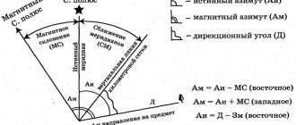
Ways to navigate the terrain without a compass
There are different techniques for orienteering in the forest. Not all methods are accurate; it is advisable to determine the sides of the horizon using several of them at once (Figure 1).
The simplest and most common methods of orientation are:
- Through the trees.
- On mosses and lichens.
- By anthills.
- On the crosses of temples (churches).
- Along the clearings.
- According to the Sun.
- By the stars.
- By the Moon.
Figure 1. Basic methods of orientation in the forest without a compass, which you will learn in detail below
Orientation by anthills, how to determine north, methods of orientation
VKTwitterOK
video content
Rating: 4.0; Votes: 1 Orientation on the ground, in the forest, orienteering in the taiga, is a primary task for a lost person. Many people have heard how to determine north by anthills, as well as other methods of orientation, but only a few know how accurate this definition of north is. Orientation, azimuth, orientation techniques Date: 2020-10-18
← Salted mushrooms, pickled mushrooms, dried mushrooms in the taiga. Procuring mushrooms for the year.
How to determine north by mosses and lichens. Methods of orientation, terrain orientation. →
Related videos
Unreliable Toilet Mount. Installing the toilet Correctly!
• Apartment and house renovation
Why do tomatoes have a gray spot? Blossom blossom on tomatoes: causes, treatment and prevention
• Garden world
The artist in chat roulette surprises. Unreleased.
• ABC of Drawing
Welding aluminum with an electrode / How to achieve good seams!
• Welder in the city
Space welding in the garage / Laser welding IPG from the Laserkat company
• Welder in the city
Never remove such leaves from tomatoes! Is it dangerous!
• Smart farming
Comments and reviews: 10
Denisenko Max is healthy, I watch your videos with interest when I have time, you tell useful practical things, everything is clear, but there are some interesting tricks. The only thing that offends is that you present it as the ultimate truth, as the only correct option, although there are always a lot of options, you can do it this way or that way, as you like best, and here you are saying that there are thousands of orienteering videos, all of each other they copy, you alone carry the truth and don’t copy anyone, well, it’s a fucking shame, everything has long been invented and written down before us. I can’t keep silent about this video, you say that everything is bullshit, it purely depends on the wind, and you show that the anthills are not on the south side, but they are all on the south, southeast, southwest, this is the south side, already approximate the direction becomes clear, and sometimes that’s enough. In smart books (which you can’t stand :) ) about anthills they write that their gentle slope is on the south side, where there is more light and warmth, THAT’S WHAT IT IS, that’s what you filmed, there are, of course, nuances and other trees somewhere , partially cover the sun, depending on this, the anthill deviates to the east or west, etc. if you have a brain, then after figuring everything out, you can navigate the anthills normally. I didn’t look at your videos on the moss and tree crowns, again you’re probably debunking myths, but all the methods described work, you just need to figure everything out normally and use your brain. If you don’t mind, I can look at other videos and leave comments. I understand that no one likes criticism, but I write calmly, without swearing or attacks.
Dmitry There is logic about the southern side of anthills and more vegetation on the trees. Like there is more light and warmth from the south. But! Those who wrote textbooks and orienteering manuals did not bother to look in the forest that open spaces and clearings could be on any side! And it is precisely to its convenience that nature strives. Maybe the earth is warmer from the east, or drier from the west, or is it a convenient clearing for ants to eat in this direction? Where will the tree have more vegetation if it grows on the south side of the clearing? Yes, a lot of this nonsense has been written. But if you go into the forest, then think with your head (preferably before you go. There is logic in everything, the main thing is not to get confused (don’t panic. We are human, everything is inherent in us.
medvedev I’ve lived in the forest all my life, I’ve trampled a lot of ground and windbreaks with my feet. but a long time ago, without any compasses, I reached the point where - moss, anthills, branches, even melted snow and all that bullshit! This is the bread and butter of natural history and geography teachers! every year they stuff children with this garbage, and then something happens, it turns out that thanks to the fate of geography, the kids ran away in the opposite direction, spitting on common sense and logic! I work as an instructor, often take beginners into the forest, and always, even adults, gray-haired pensioners say - What if we get lost in the anthills and walk back through the moss! I'm shocked.
Albert I am not a survivalist or a taiga dweller, an ordinary tourist-fisherman-mushroom-picker who lives in a metropolis and loves going out into nature. A compass is a must-have item in your pocket. I also noticed a long time ago that the anthills are complete garbage. The same garbage, by the way, with moss on trees) at least here. Thank you very much to Maxim for conveying something useful and necessary to people like me (urban ignoramuses and ignoramuses)
mayorua Well, from 10 anthills you can calculate the southern sector at 180 degrees. How and how accurately to calculate its central secant vector to the south itself, when the anthills are at a distance from each other, is a mystery. I support. This is all bullshit. I myself carried out the same experiment many years ago, with the same result. The location is influenced by many things, microclimate, relief and who knows what.
Angry Come on! What the hell are anthills and annual rings? The method works in the case of a spherical body in a vacuum. Where exactly does the sun heat during the day in a specific place - that’s where the ants will make a gentle slope. They don't have a compass! And if you also went into the forest without him - good luck to you, good luck, and hang in there. Or what about Dimon?
Forge Maxim. very big request! Please make a video about which compasses to buy and how to use them correctly, otherwise a lot of people actually don’t know how to use a compass and are talking all kinds of heresy. dot the dots and explain it so that even a child can understand it. I beg you very much! thanks in advance!
EarthGuard anthills do not become attached to trees. There are trees everywhere in the forest. Wherever you build an anthill, it will end up near some tree. and I’ve never even heard of a tree in anthill orienteering. They taught that there would be a long side on the south side. these are the wrong ants and they make the wrong acid!
Kozyr Maxim, thank you! Great idea to understand these tips. But. I agree with the questions raised here. To complete the picture and have accurate knowledge, you need to: 1) check lonely trees with an anthill. 2) the direction of the slope of the anthill. Thanks again! Everything is informative and interesting.
Andrey In general, I don’t see the point in determining the direction of the world when you get lost. You need to constantly monitor your position relative to the cardinal directions and the direction of the path. You can make a circle, you think that you need to go back to the south, but in fact you need to go in the opposite direction
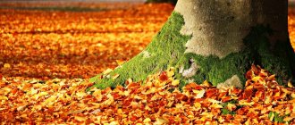
Tree navigation
For more accurate orientation in the forest, it is advisable to take a closer look at several tree trunks, and not draw conclusions from one or two.
There are several ways to navigate the area using trees:
- If you look closely at the trees, you can see that there are more leaves on the south side and they are denser, while on the north side there are fewer leaves. The reason for this phenomenon is that in the northern hemisphere of the planet the sun passes on the southern side, and there is more heat on this side (Figure 2).
- On the northern side, the tree bark is darker and rougher. This is best observed in pine, larch, birch, and aspen.
- Usually, after rain, pine trunks darken on the northern side of the tree, which is caused by a secondary crust that grows faster on the northern side.
- Mushrooms on trees often grow on the northern side of the trunks, this is especially noticeable in dry times (the northern part of the tree retains the moisture necessary for the growth of the fungus longer).
Figure 2. Trees in a forest give us several ways to determine direction.
Orientation by mosses and lichens
One of the most well-known methods of orientation on the ground is by mosses and lichens. On the northern side of tree trunks and stones, moss grows more abundantly than on the southern side, due to the fact that the sun dries it less (Figure 3). Moss almost always grows on old stumps, which can also serve as a guide: although a stump may be covered with moss on all sides, it is wetter on the north side.
Figure 3. Moss grows on the north side of stumps and trees.
It is also worth paying attention to the soil around the stone: on the south side it is relatively dry, on the north it is more humid.
Orientation by moss and lichen
Mosses and lichens do not like heat and light, so they grow in the shady side. This means that where there are mosses and lichens, there is north; on the south side there is less or no moss at all. Now orienteering on moss will not present you with any difficulties.
You can also determine the direction by looking at the soil around the stone. On one side it is relatively dry (south), and on the opposite side it is wetter (north).
Usually an old, rotting stump is overgrown with moss on all sides. But to determine where north and south are, you need to check the moisture content of the moss, not the soil.
The fact is that mosses and lichens prefer cooler and more humid places. They are so sensitive that they are rarely found on the south side of trees (they do not like light, sun rays and heat). However, there are humid places in themselves (swamps, for example), and there are also many places in which trees are completely protected from the sun's rays hitting them.
We suggest you read: How to distinguish insect bites
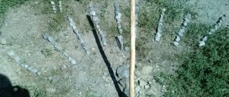
Orientation by anthill
Ants are heat-loving insects and you can navigate to the cardinal points thanks to the anthill. Ants usually build their colony on the south side of tree trunks. In order for the anthill to warm up better, the southern slope of the “ant house” is flatter than the northern one (Figure 4).
Figure 4. Considering the abundance of ants in our area, they are good to use for navigation
Anthill navigation
Another natural compass that will always help you find the right direction in the forest is anthills . Most of them are located on the south side of a tree, stump, or bush, since ants are heat-loving insects. The southern side of the anthill is usually sloping, the northern side is much steeper. Orientation by anthill. Navigating an anthill is quite simple to remember and understand. In the tundra, as well as in white moss forests (more: What types of forests) and taiga swamps in the north of the European part of the USSR, in Western and Eastern Siberia, in the Far East, lichens (moss moss, or reindeer moss) of the genus Cladonia grow, which serve as irreplaceable food for reindeer, especially in winter. Sources of valuable antibiotics and enzymes, they can also serve as a compass. Darker than the entire lichen, the tips of their branched bushes always face north. Therefore, when going north, you see the dark surface of the moss (lichen) cover, when moving in the opposite direction, that is, to the south, the dark color is not visible, and the bushes seem lighter
Orientation by temples and glade pillars
If you need to get your bearings and an Orthodox Church is visible not far away, pay attention to the cross crowning the dome of the church. The lower oblique (diagonal) crossbar of the cross points with its lower part to the south, and with its upper part to the north (Figure 5).
Orthodox churches are built strictly with orientation to the cardinal directions.
If you find a clearing in the forest and move along it, sometimes you can find a post with numbers indicating the number of the “square”. A cutting post can help determine the cardinal directions: the numbers with the lowest value point to the north.
Figure 5. Clearing pillars and Orthodox churches will also help you determine the direction
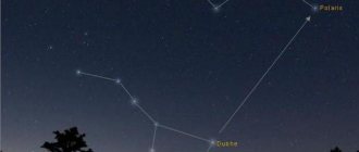
Orientation by the stars
Orientation by the stars is one of the most reliable options for determining the cardinal directions. At the same time, this method can be difficult for a beginner - not everyone can find the right constellation. The main thing is to find the North Star in the sky; it is not the brightest in the night sky, as many people believe.
Navigating by the stars takes some practice.
If you may need to determine the cardinal directions from the starry sky in the future, it is advisable to practice in familiar (not camping) conditions.
In the Northern Hemisphere, the North Star is always above the northern point of the horizon (the difference between the North Pole and the North Star is 1°), this makes it an indispensable “assistant” for orientation on the ground (Figure 6).
Figure 6. The North Star has been helping to determine direction for several hundred years.
In the starry sky you need to find a specific figure of 7 bright stars of the Ursa Major constellation, visually reminiscent of a ladle with a handle. 3 stars “form the handle”, 4 – the “capacity” of the bucket itself. It is necessary to speculatively connect 2 stars (Dubhe and Merak) located on the right edge (wall) of the bucket with a straight line. Next, continue the straight line (conditionally set aside 5 times the distance separating the mentioned Dubhe and Merak) to the star located on the edge on the represented “handle” of Ursa Minor (also a smaller “bucket” of 7 stars). This star is Polaris (always points exclusively to the north). The height of the star above the horizon coincides with the latitude of the observing person.
In the Southern Hemisphere, the starry sky is radically different from the Northern Hemisphere. The main reference point for the cardinal directions in the Southern Hemisphere is the Southern Cross constellation (Figure 7), consisting of 5 bright stars. 4 stars are speculatively arranged in the shape of a cross. One of the conditional lines will exceed the second in length - one of the stars of the Southern Cross is observed further than the others, you get a kind of cross with a handle that needs to be visually extended 4 times and “drawn” vertically to the horizon line - the south has been found! If you wait for the moment when the Southern Cross stands vertically in the sky, then the handle will be directed strictly south. When observing, it is important not to mistake the False Cross (not pointing to the South Pole) for the Southern Cross.
Figure 7. Another assistant in the sky at night - the Southern Cross
You can also use the constellation Orion, which points to the east and west, for orientation by the stars. In practice, orientation by Orion is much more difficult than by the Southern Cross. For orientation, 3 bright stars on the constellation belt are used: at the moment of sunrise they are directed to the east, at the moment of sunset - to the west.
According to the sun
How to navigate in the forest by the sun? This method can only be used in clear weather. There are several methods for determining cardinal directions.
The sun always rises from the eastern side and sets from the western side. In the middle of the day it is located in the south (in the northern part of the globe). If you are lost in the forest of the Southern Hemisphere, then at noon the sun will be from the north.
How can you navigate in the forest using a watch in sunny weather? The following method will help you determine the north side:
- You need to stand so that the hour hand is facing the sun.
- Mentally you need to draw the angle between the hour hand and the “13” (or “1”) mark on the dial. Then it needs to be visually divided in half by a straight line (bisector).
- Until 13:00, north will be to the left of the sun, and after that it will be to the right. In the Southern Hemisphere, the position of the north will be exactly the opposite.
If you can find a stick in the forest, you can try to make a gnomon pole. However, you can only navigate with it at midday. The stick needs to be dug into the ground. Around noon, the shadow of the pole will point north. For accurate orientation, you need to choose a long enough stick.
Orientation by the moon
Navigating by the moon is quite difficult, and the accuracy is not very high. But sometimes this is the most affordable way. The moon is often visible even through dense cloud cover when the stars are not visible.
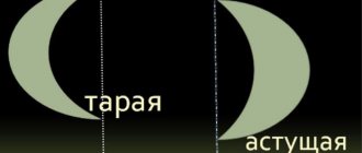
The moon goes through a series of phases of solar illumination:
- New Moon – The Moon is virtually invisible.
- First quarter – the right half of the Moon is illuminated.
- Full moon - the entire disk of the moon is illuminated.
- Last quarter – the left half of the Moon is illuminated (Figure 8).
If the crescent moon conventionally resembles the letter “P” - the Moon is growing (before the full moon, including the first quarter), if the letter “C” is aging (after the full moon, including the last quarter). Growing is more often observed in the evening, aging - in the morning. The full moon is the most favorable time for determining the directions of the horizon.
Figure 8. Moon phases
In the first 1/4 the Moon is approximately located:
- 19:00 – south;
- 1:00 – west;
- 7:00 – not visible.
During a full moon, the Moon is approximately located:
- 19:00 – east;
- 1:00 – south;
- 7:00 – west.
In the last 1/4 the Moon is approximately located:
- 19:00 – not visible;
- 1:00 – east;
- 7:00 – south.
You can also navigate with the help of a clock, just like by the daylight, but it is not the time of true noon that is determined (a person orients himself by the Sun), but the moment of the upper culmination. During the full moon, this moment and local midnight coincide, orientation along the full disk of the Moon is carried out similarly to orientation towards the Sun.
The problem is that it is impossible to speculatively determine whether the Moon is in the full moon phase.
For several days before and after the full moon, the appearance of the night star is almost unchanged, and the deviation, which is caused by an incorrect phase, can be very significant; the lunar disk shifts by 12° per day.
In 1/4, the Moon reaches its climax 6 hours before midnight, in the last 1/4 - 6 hours after local midnight. Since the 1/4 moment is visually determined easily, the orientation is performed more accurately.
There is a general rule for orientation with the help of the Moon - you need to speculatively divide the diameter of the night luminary into 12 shares and determine how many parts the unlit part of the Moon occupies - exactly how much will the time of culmination differ from the local midnight. The waxing moon culminates before 00:00, the aging moon - after.
The greatest deviations with this method are possible closer to the new moon and full moon. With some experience, the sides of the horizon can be determined with an error of up to 10-15°.
Sun orientation
In clear weather, you can navigate the area using a mechanical watch. The large hand of the clock must be turned so that it points directly at the sun. Afterwards, you need to visually draw the angle between the hand aimed at the sun and 13 o’clock (1 hour). Through a given acute angle we draw a bisector dividing the acute angle in half. We mentally imagine an arrow lying on this bisector; this arrow will point to the north. Before noon we divide the angle located before 13:00, after noon we divide the angle formed after 13:00 (Figure 9).
Figure 9. The sun, like the moon, can help determine direction.
In the absence of a mechanical watch, you can roughly draw an analogue of its dial on the earth's surface or paper.
In the Southern Hemisphere, the sun is located on the other side. Accordingly, you need to navigate by the clock or “analogue” exactly the other way around - by following the procedure described above, you can determine the south, not the north.
It is also worth considering the well-known fact that in the Northern Hemisphere the sun rises in the east, sets in the west, and at its zenith the sun is in a southerly direction. In the Southern Hemisphere, the solar disk at its highest point points north, not south. Such orientation, of course, is very conditional.
Orientation by the sun and stars
To navigate by the Sun on a bright sunny day, you should wait until midday. At this time, the luminary is at its zenith, any shadow cast by objects becomes short. You should stand with your back to the luminary; the tourist’s shadow will indicate the direction to the north. The south will be behind the traveler. On his right hand there will be an eastern direction, on his left hand - a western direction.
In the off-season, on spring and autumn days, the sun will rise strictly in the east and set in the west. At noon in any season, the star is in the south and every shadow points to the north. On winter days, the sun will rise from the southeast and set from the southwest. On summer days, the sun will rise from the northeast and set from the northwest.
Any traveler has an idea of the constellations of his northern sky. Today, almost every schoolchild can find the stars Ursa Major and Ursa Minor in the sky. But although tourists may theoretically know that the North Star is the end star on the tail of Ursa Minor, finding it can be quite difficult.
Table: determining parts of the world by the sun