- History of orienteering
- Types of orienteering
- Orienteering disciplines
- Equipment for orienteering
- Orienteering maps and signs
- Orienteering training videos
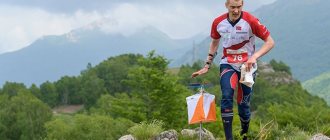
Orienteering is a sport where participants cover a distance by passing checkpoints. The route is not known to the athletes in advance; they receive a map of the area before the start. Orienteering is carried out mainly on rough terrain, sometimes in the city. The length of the distance is usually 5-15 kilometers, but there are also longer, daily competitions (rogaines).
Over the more than century-long history of orienteering, several types and disciplines of this sport have developed. In this article we will talk about the history of orienteering, its types and features, equipment and symbols on the map.
Source: vjsport.fi
History of orienteering
Orienteering as a sport originated in the Scandinavian countries at the end of the 19th century. At first, only military personnel participated in the competition. The first civilian competitions were held in Norway in 1897. The basic principles of orienteering appeared: competition rules, types of distances, choice of landmarks for setting checkpoints, age categories of participants.
At the beginning of the 20th century, orienteering spread throughout the USSR and European countries, and national championships began to be held. In 1961, the International Orienteering Federation was founded in Denmark, which united national orienteering federations.
In the USSR, the first orienteering competitions were held in 1939. Interestingly, it was a night start, where the participants covered a distance of 20-25 km; they only had to find one checkpoint. At the beginning of the development of orienteering in the USSR, there was the concept of “control load” - the weight that the athlete was allowed to carry, different for men and women. Back then, orienteering was considered a form of tourism, not a sport. Over the years, orienteering developed, and all-Union championships began to be held. After the collapse of the Soviet Union, Russia became a member of the International Orienteering Federation.
At the beginning of the development of orienteering, the Scandinavian countries were the leaders. Later they were joined by Russia and the CIS countries. Russian athletes regularly win medals at international championships. In many cities of Russia, the “Russian Azimuth” launch is regularly held.
Types of orienteering
The International Orienteering Federation recognizes 4 types of orienteering:
Running orienteering
The classic and most popular type of orienteering. Competitions are held by running in the city and outdoors, on any surface and impenetrable thickets. In the city, ordinary running equipment is suitable, but for the forest there are special features:
- Clothing that protects against insects and thorny plants is made of durable, but light and breathable materials. Special socks or leggings, leggings or capris;
- Shoes with an aggressive tread. Special orienteering shoes or trail running shoes (Inov8, Icebug, VJ-Sport, NVII, Jalas, );
- Map, compass, flashlight (for night navigation).
Ski orienteering
It is carried out on cross-country skis on a pre-prepared “grid” of ski tracks. Unlike cross-country orienteering, in ski orienteering it is more difficult to “cut short” and quickly change direction if there is an error in navigation. There are different types of ski tracks along the distance: fast and wide, slow and narrow. Therefore, there is always a choice about which route will be faster.
- Skate skis, boots, poles. Standard ski equipment is usually used, but sometimes athletes choose stronger aluminum poles instead of lightweight carbon ones, wider tips and shorter skis;
- A tablet with a map and compass, which is attached with straps to the skier’s chest.
Bicycle orienteering
The distance is covered by bicycle along paths and roads with different surfaces. The equipment is standard, like that of an MTB racer, except for a special table on the handlebar for a map: cycling jersey and cycling shorts, helmet, gloves, clipless pedals and cycling shoes, a tablet with a map and compass.
CARTOGRAPHIC SYMBOLS
4. Explanatory symbols are digital and alphabetic inscriptions characterizing objects, for example, the depth and speed of river flows, load capacity and width of bridges, forest species, average height and thickness of trees, width of highways. These signs are placed on the main areal, linear, and non-scale areas.
- Related Posts
- What is the difference between work experience and insurance experience?
- Rights in case of divorce regarding a child
- Is income tax deducted from sick leave?
« Previous entry
Orienteering disciplines
Orienteering is represented in several disciplines. They differ in the order of passing checkpoints, the area and length of the route, completion time, penalties, and calculation of results.
Orientation in a given direction
The participant’s goal is to pass checkpoints in a given order. The order of passing checkpoints is shown on the map, which is issued before the start. The winner is the athlete who completes the distance in the correct order in the shortest time.
A special type of orienteering in a given direction is orienteering through a sports labyrinth, or ultrasprint. The area of the track (labyrinth) is very small, and the length of the distance is 100-500 meters. Artificial obstacles have been created on the route (as opposed to natural obstacles during orienteering in natural conditions).
Orientation by choice
Participants go through the route in any order. The order of the distance is not marked on the map: only the starting points, checkpoints and finish points are indicated. There are three types of orientation to choose from:
- Completing the distance in the shortest time
- Completing a distance with a certain number of points (which are awarded for passing checkpoints) in the shortest time
- Completing the distance in a certain (control) time with the greatest number of points. Points are awarded for passing each checkpoint. A fine is given for exceeding the appointed time.
Source: flickr.com Federazione Italiana Sport Orientamento
Orientation on a marked course
The goal of the participants is to go through as many checkpoints as possible and mark them on the map (on which initially only the start and finish are marked). At the finish line, the judges check the cards of the participants. If an athlete marks a checkpoint inaccurately, a penalty is imposed - extra time or penalty loops. The result is the sum of the time spent completing the distance and the penalty earned.
Orientathlon
Orientathlon is a combination of disciplines in a given direction and on a marked course. Conducted only for skiers. Ski tracks are marked on the map, but control points are not marked.
Source: flickr.com Federico Daprà_2
Trail orienteering
The discipline of orienteering, originally created for people with disabilities. Gradually, this type of orienteering became popular among amateurs; now everyone can take part in trail orienteering.
The map shows the paths and points allowed for movement. Prisms or flags are located not far from the control points. The athletes' task is to determine which of the prisms corresponds to a point on the map. The athlete who correctly identifies the most matches wins. The time taken to complete the distance is not taken into account.
Classification by other criteria
| Participant interaction | |||
| individual | relay | group | |
| Organization of the start | |||
| separated | handicap | general | |
| Recording of results | |||
| personal | personal-team | team | |
| Determining the result | |||
| one-time | multiple | qualifying | |
| Competition time | |||
| daytime | night | ||
Orienteering competitions are held among amateurs and professionals of all ages. There are competitions that last several hours and competitions that can last a day (rogaining).
Source: flickr.com Viktor_K79
Equipment for orienteering
Equipment for orienteering depends on the type of competition. Ski orienteering requires skis and poles, and bicycle orienteering requires a bicycle. In addition to specific equipment, there is general equipment.
Orienteering compass
Compasses for orienteering are lightweight and compact. They are attached to the wrist, on the thumb (such compasses are suitable for professional orienteers) or hung around the neck. If you go skiing or biking, the compass is attached to the tablet.
Orienteering athletes use liquid compasses with a magnetic needle. In such compasses, the needle is set to the north position as quickly as possible (in 0.5-2 seconds) and does not move while moving.
Source: 2wheelchick.cc
Tablet for attaching the map to the handlebars of a bicycle or on the chest
Everyone is given chips to mark at checkpoints. In night orienteering, a flashlight is used, and in ski and bicycle orienteering, a tablet is used (a special device for attaching a map in conditions when your hands are busy).
Legendary
A special holder for symbols on the map, with which it is easier to find the desired point.
Identification of the swamp on the site plan
Swamps, creeks, and sticky places also fall into this category. In some plans of the area, signs indicating objects of marshy nature are characterized by inaccurate miniatures (Figure 7).
The designation of the swamp on the site plan will look like one of the following images:
READ ALSO: What To Do First Gate Or Fence
- A passable swamp during the warm season. The main vegetation consists of reeds and moss. Depth - less than half a meter. It is depicted as a canvas of parallel sections of blue color with a wide gap.
- Difficult swamp. Depth ranging from half a meter to a meter. Appearance: a canvas of parallel stripes with an average indentation.
- Impenetrable swamps. Depth from one meter to five. They are depicted as continuous parallel stripes, with partings from islands of vegetation/soil/roots.
Figure 7. Symbols of swamps
Orienteering maps and signs
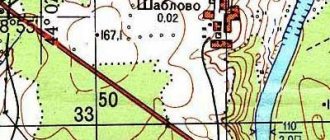
Sports map is a type of topographic map for orienteering. The route is marked on it, and the order of passing the distance and checkpoints (for some disciplines) can be marked. Conventional signs of landscape features are also used. The first orienteering maps were produced in 1952.
The orienteering map in a given direction shows:
- triangle - start
- double circle - finish
- single circles with numbers - checkpoints and the serial number of each of them
- line - route
An example of a map for orientation in a given direction. Source: yunomsk.ru
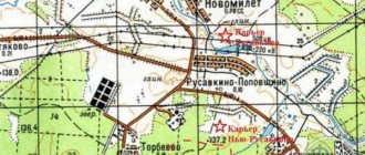
On the map for orientation by choice, the same symbols are used - a triangle, a double circle and single circles. But the checkpoints are not connected by a line; the participant builds his own route, finding checkpoints in any order.
An example of an optional orienteering map. Source: yunomsk.ru
On the map, only a triangle (start) is indicated orientation on the marked route The competition participants apply checkpoints themselves using a needle, pin or a special punch; the permissible puncture diameter is 1 mm. Additionally, you can draw a cross through the puncture with a felt-tip pen. The participant must check all checkpoints.
Map for navigation along a marked route
Map for navigation along a marked route
On a sports topographic map there are special signs of landscape features - landmarks. They can be linear, areal, point, and relief object signs (including linear, area, and point landmarks).
Linear landmarks on the map are indicated by lines. They designate roads (highways, trails, railroads), water (lakes, rivers, swamps) and other objects (fences, power lines).
Linear landmarks
Area landmarks designate terrain features that are based on an area. For convenience, the difficulty of passage is indicated, for example, an easy-to-run forest, a slow-run forest, an irresistible river.
Point landmarks are artificial objects (wells, water towers, pipes), as well as small natural objects (stones, hillocks, anthills). These objects do not have a significant area and extent and are indicated by different points.
Point landmarks
Relief features are signs consisting of horizontal lines that correspond to a certain level of elevation on the ground. Such signs indicate, for example, holes, slopes, cliffs.
Horizontal. Designation of relief objects on the map
Relief objects
All symbols for orienteering
Legend
The legend is an area of the sports map with a description of control points on the ground. The checkpoint can be located in an open space, in a hole, next to some natural object or artificial structure - this is specified in the legend.
Orienteering is interesting because it requires versatile development. You need not only endurance, speed and developed coordination. It is important to make decisions quickly, think through a route, keep several objects in mind at the same time, calculate forces, orientate well using a map and compass - these are the main skills of an orienteering athlete.
Conventional signs and designations of topographic maps - LikBez
Correct map reading is ensured by a good knowledge of symbols. The symbols of topographic maps of all scales are overwhelmingly the same in their outline, and therefore knowledge of the symbols of maps at scales 1:25000, 1:50000 and 1:100000 makes it possible to read topographic maps of smaller scales. Symbols for maps at scales 1:200000, 1:500000 and 1:1000000, which differ from symbols for topographic maps at larger scales, are given in separate tables of the reference book (pp. 43-55).
We recommend reading: Which value is greater, cadastral or market value?