What is a temperate climate zone and where is it located?
As you know, our planet is divided into climatic zones - territories with a uniform climate that encircle the Earth.
They differ from each other not only in the dominance of a certain air mass, which, by the way, determines the boundaries of the belt, but also in atmospheric pressure, temperature and amount of precipitation. In total there are 13 climatic zones: 7 main and 6 transitional. These include the so-called moderate. Let's look at it in more detail.
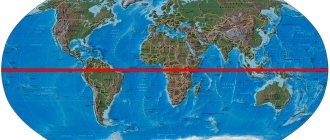
The temperate climate zone is the main climate zone extending between 40-70° north latitude and 40-55° south latitude. More than half the surface of the temperate zone in the Northern Hemisphere is occupied by land, while in the Southern Hemisphere almost everything is covered with water.
Forests of the subequatorial belt
These are deciduous evergreen forests, which are located along the eastern edge of South America, along the coast of Indochina, and in northeastern Australia. There are clearly two seasons here: dry and wet, the duration of which is about 200 days. In summer, equatorial humid air masses dominate here, and in winter, dry tropical air masses dominate, which leads to the falling of leaves from trees. The air temperature is constantly high, +20-30°C. Atmospheric precipitation decreases from 2000 mm to 200 mm per year. This leads to a lengthening of the dry period and to the replacement of evergreen, permanently moist forests by seasonally moist deciduous ones. During the dry season, most deciduous trees do not shed all their leaves, but a few species remain completely bare.
Best articles : Neapolitan Mastiff: a dog for strong people
The climate is temperate.
The climate in temperate latitudes is determined by the proximity of the territories to the ocean. There are 5 types of climate inherent in this zone:
Monsoon climate.
It is formed on the eastern edge of Eurasia. The main feature of this climate is the sharp change in humidity throughout the year. For example, in summer there is a lot of rainfall, which means the humidity is high. In winter it’s the other way around: the weather is dry and the humidity is very low.
The monsoon climate of temperate latitudes prevails in the Russian Far East (Primorye, the middle reaches of the Amur River), in northern Japan, and also in northeastern China. In winter, it is formed as a result of the removal of continental air masses to the periphery of the Asian anticyclone, and in summer, its occurrence is influenced by marine air masses. All indicators (precipitation, temperature, humidity) vary throughout the year, with the highest levels observed in summer.
Maritime climate.
It is formed under the influence of the atmosphere of oceanic spaces. It is characterized by slight temperature fluctuations throughout the year and day, high humidity, and a 1-2 month delay in the highest and lowest temperatures. The greatest amount of precipitation falls in winter; autumn here is warmer than spring. The warmest month is August, and the coldest is February, all this due to the fact that water masses heat up and cool more slowly than land. The air of a marine climate is characterized by a high content of sea salts and low dust content.
Sharply continental climate.
It is found only in the Northern Hemisphere, since there is no land in the temperate latitudes of the Southern Hemisphere, which is why continental air masses do not form.
This climate is formed in the south of Siberia and in its mountains. Summer in these areas is warm and sunny (+16-20°), and winter is frosty (-25-45°). Precipitation occurs more frequently in summer than in winter, with its peak occurring in July.
The weather here is rich in anticyclones, the humidity is low, there is little precipitation (400 mm), and the winds are not strong. The sharply continental climate is also characterized by high fluctuations in annual and daily temperatures.
Temperate continental climate.
This type of climate is also formed in the Northern Hemisphere for the same reason. It is most widespread in Siberia and Transbaikalia.
In winter, the so-called Siberian (Asian) anticyclone forms here: the air cools to -30°-40°. This time of year is longer compared to summer, but more precipitation falls in the warm season (50-60 mm). The average annual precipitation is 375 mm.
The temperate continental climate is also characterized by: little cloudiness, rapid heating of the air during the day and its sharp cooling at night, and deep freezing of the ground.
Continental climate.
In temperate latitudes, this type of climate is characterized by a large annual and daily amplitude of air temperature. Winters here are cold, summers are hot. Unlike the maritime climate, the continental climate has a lower average annual temperature and humidity, as well as an increased level of air dust. Partly cloudy skies are common here and annual precipitation is also low. In addition, the continental climate is characterized by strong winds (dust storms occur in some areas).
general characteristics
The main feature of a temperate climate is the presence of four seasons: two of them are main, winter and summer, and two intermediate ones - autumn and spring. The average temperature of a cold month is below 0 °C, and a warm month is above +15 °C. In winter, the temperate zone is covered with snow. The annual precipitation level is 500-800 mm.
The territory of the temperate zone is covered by a moderate air mass, characterized by low atmospheric pressure and high humidity. The temperature regime always changes depending on the seasons, so the seasons in the temperate climate zone are clearly defined: winter is snowy and harsh, spring is warm and sunny, summer is hot and sultry, and autumn is the season of golden leaves and heavy rains with winds. Temperatures in the temperate zone in winter drop on average to 0 °C, and in summer they rise above +14 - +21 °C. The average annual precipitation ranges from 450 to 700mm.
Temperate climates can be divided into four types:
- Maritime climate. Characteristic of coastal areas and oceans. Winters are mild, summers are not hot, there is a lot of precipitation, and humidity is high.
- Temperate continental climate. The most common and stable. Summer is hot, winter is cold, there is little precipitation. The main features of this climate are cloudiness, high winds and dust storms. The maritime climate predominates on the coasts of the Atlantic and Pacific oceans. The Cordillera is a natural boundary separating the interior from the coast with a maritime climate. On the European coast, except for Scandinavia, temperate sea air predominates. The sea air brings with it frequent cloudiness, which is why spring is long here.
- Sharply continental climate. Characteristic of areas remote from oceans and seas. Winters in these regions are very harsh and frosty. Summer is short and cool, with high rainfall.
- Monsoon climate is not typical for the temperate zone, therefore it is rare; it prevails in the tropics and subtropics. Weather conditions depend on the monsoon circulation (seasonal winds).
Finished works on a similar topic
Course work Temperate climatic conditions 490 ₽ Essay Temperate climatic conditions 240 ₽ Test work Temperate climatic conditions 240 ₽
Receive completed work or specialist advice on your educational project Find out the cost
Average temperature values for the following climate types:
- maritime climate - in summer +12 °C - + 16 °C, in winter from 0 °C to +4 °C;
- sharply continental - in summer +18 °C - +25 °C, in winter from -7 °C to 25 °C.
- temperate continental - in summer +14 °C - +18 °C, in winter from 0 °C to - 10 °C.
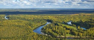
Natural zones of the temperate climate zone.
In temperate latitudes, there are 3 main types of natural zones: forests, forest-steppes, and arid zones.
Forest Zone
Taiga
The forests are characterized by taiga, mixed and broad-leaved forests.
Taiga is located in two continents: North America and Eurasia. Its area is 15 km2. The relief is predominantly flat, rarely intersected by river valleys. Due to the harsh climate, the soils are weak and large deciduous trees do not grow in the taiga. Moreover, needles containing toxic substances falling from coniferous plants deplete the already scarce soil.
Winters here are frosty, dry, and last more than six months. Summer is short but warm. Spring and autumn are also very short. The highest temperature in the tundra reaches +21°, and the lowest - -54°.
Mixed forests
Mixed forests can be called a transitional link between taiga and deciduous forests. It’s easy to guess from the name that both coniferous and deciduous trees grow in this zone. Mixed forests extend in Russia, New Zealand, North and South America.
The climate of the mixed forest zone is quite mild. In winter the temperature drops to -15°, in summer it reaches +17°-24°. The summer period here is warmer than in the taiga.
This zone is also characterized by layered vegetation: the appearance changes with the change in height. The highest tier consists of oaks, spruces and pines. The second tier includes birch, linden and wild apple trees. The third is viburnum and rowan (the shortest trees), the fourth consists of shrubs (rose hips, raspberries). The last, fifth, is filled with herbs, mosses and lichens.
Broadleaf forests
Broadleaf forests consist mainly of deciduous plants. The climate in this zone is gentle: winters are mild, summers are long and warm.
In especially dense parts of the zone, the grass cover is poorly developed due to the dense crowns of trees. The Earth is covered with a dense layer of fallen leaves, which, when decomposed, saturate the forest soils.
Forest-steppe zone
Forest-steppe is a belt of vegetation in Eurasia, characterized by alternating forests and steppes. As you move south, the amount of trees and precipitation decreases, steppes appear, and the climate becomes hotter. Moving in a northerly direction, one can observe the opposite picture.
About the climate: the forest-steppe is characterized by cool winters with plenty of snow and hot, humid summers. The average temperature in January is -2°-20°, in July - +18°-25°.
The soil cover of the forest-steppe contains a lot of humus and is characterized by a stable structure. These soils can be cultivated, but without excessive tillage.
Dry zones include steppes, semi-deserts and deserts.
Arid zones: steppes, deserts and semi-deserts
Steppes
The steppes are located between the semi-desert and forest-steppe zones. The main feature of this zone is aridity.
The climate here fluctuates between moderate continental and sharp continental. Summers are very sunny, and winters are windy, although with little snow. The average annual precipitation is 250-450 mm.
Steppe soils are represented mainly by chernozems; as you move south, they become less fertile and are replaced by chestnut soils with an admixture of salts. Due to its fertility, steppe soils are used for growing various garden and agricultural crops, and are also used for pastures.
Deserts
Deserts extend far from the oceans, making them inaccessible to moisture-carrying winds. Hence their main property is excessive aridity. Humidity is practically zero throughout the year.
Due to the dry air, the land is not protected from solar radiation, so during the daytime the temperature rises to +50°: it is sizzlingly hot. However, there is a sharp cooling at night due to the rapid cooling of the soil. Sometimes daily temperature amplitudes reach 40°.
The topography of deserts differs significantly from other zones. There are mountains, plains and plateaus here, but they are created by the wind and stormy water flows after rainstorms, so they have an unusual appearance.
Semi-deserts
Semi-desert is a transition zone from steppe to desert. It extends in Eurasia from the Caspian lowland to Eastern China.
A sharply continental climate prevails here, winters are quite cold (-20°). The amount of precipitation per year is 150-250 mm.
The soils of semi-deserts are light chestnut (poor in humus), as in the steppe; brown desert soils are also found. As you move south, the desert properties intensify, and the steppe ones fade away. The characteristic vegetation is wormwood-grass, growing in fragments.
Monsoon climate
Monsoon climate is a climate characteristic of areas of the planet where atmospheric circulation in the form of monsoons takes place.
Characteristic features: almost complete absence of precipitation in winter and its sharp predominance in summer; significant air humidity in summer. Thus, in India (Mumbai) up to 600-800 mm of precipitation falls in summer, and from 3 to 8 mm in winter.
Monsoon climate occurs mainly in areas where the wind changes direction in summer and winter and carries dry air or moisture. Monsoon climates are rare in temperate latitudes. Basically it is a continuation of the subtropical or tropical monsoon. In the equatorial belt, monsoons are very weakly expressed or absent altogether, which is explained by the weak annual change of winds.
Are you an expert in this subject area? We invite you to become the author of the Directory Working Conditions
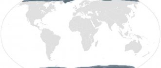
Countries of the temperate climate zone.
The temperate climate zone occupies a fairly vast territory. It extends across Eurasia, America and covers both the Northern and Southern Hemispheres.
North hemisphere:
- North America: USA, Canada;
- Europe: Hungary, Czech Republic, Poland, Slovakia, Ukraine, Belarus, Croatia, Austria, Switzerland, Georgia, Armenia, Azerbaijan, Italy, France, Great Britain, Romania, Bulgaria, Serbia, Montenegro, Belgium, the Netherlands;
- Asia: North Korea, China, Japan, Kyrgyzstan, Uzbekistan, Turkmenistan, Mongolia, Kazakhstan and part of Russia.
Southern Hemisphere:
- South America: Chile, Argentina;
- Tasmania Island;
- French South Polar Territories;
- New Zealand.
Temperate maritime climate
A temperate maritime climate is a climate that forms over the oceans and extends to the coastal areas of continents.
Temperate maritime climates are characterized by:
- positive values of average annual temperatures;
- low daily and annual temperature range;
- cool summer;
- mild winter;
- significant amount of precipitation (900 – 1200 mm);
- high humidity.
Precipitation amounts vary greatly depending on the meridian location of mountain ranges. Thus, in Bergen (Europe, west of the Scandinavian mountains) more than 2500 mm of precipitation falls per year, and to the east of the mountains, in Stockholm - 540 mm. In North America, to the west of the Cascade Mountains falls from 3000 to 6000 mm per year, and to the east - 500 mm.
The annual maximum and minimum temperatures occur in February and August (in the Northern and Southern Hemispheres, respectively), which is determined by the high heat capacity of water.
In temperate latitudes, the temperate maritime climate is characterized by abnormally mild winters. The average temperature in February (the coldest month) can be positive and correspond to the average temperature of the cold months of the subtropical zone. There is no permanent snow cover. The average temperature in August (the warmest month) is lower than at similar latitudes in continental regions.
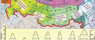
Temperate climate zone in Russia
On the territory of the Russian Federation, this belt is the longest and most populated. In this regard, it is divided into 5 regions that differ from each other in climate:
- Magadan and the Sea of Okhotsk are located in the maritime climate region.
- The monsoon climate region is made up of Vladivostok and the Amur River, which flows into the Sea of Okhotsk.
- The sharply continental climate consists of Chita, Yakutsk and Lake Baikal.
- The continental climate includes Tobolsk and Krasnoyarsk.
- Moscow, St. Petersburg and Astrakhan are located in the temperate continental climate area.