vibrations of the Earth caused by sudden changes in the condition of the planet's interior. These vibrations are elastic waves propagating at high speed through the rock mass. The most powerful earthquakes are sometimes felt at distances of more than 1,500 km from the source and can be recorded by seismographs (special highly sensitive instruments) even in the opposite hemisphere. The area where vibrations originate is called the earthquake source, and its projection onto the Earth's surface is called the earthquake epicenter. The sources of most earthquakes lie in the earth's crust at depths of no more than 16 km, but in some areas the depths of the sources reach 700 km. Thousands of earthquakes occur every day, but only a few of them are felt by humans.
Also on topic:
LAND BUILDING
Mentions of earthquakes are found in the Bible, in the treatises of ancient scientists - Herodotus, Pliny and Livy, as well as in ancient Chinese and Japanese written sources. Until the 19th century Most reports of earthquakes contained descriptions heavily flavored with superstition and theories based on scanty and unreliable observations. A. Perry (France) began a series of systematic descriptions (catalogs) of earthquakes in 1840. In the 1850s, R. Malle (Ireland) compiled a large catalog of earthquakes, and his detailed report on the Naples earthquake in 1857 became one of the first strictly scientific descriptions of large earthquakes.
Tectonic earthquakes
Also on topic:
GEOLOGY
arise as a result of a sudden release of stress, for example, during movement along a fault in the earth’s crust (research in recent years shows that deep earthquakes can also be caused by phase transitions in the Earth’s mantle, occurring at certain temperatures and pressures). Sometimes deep faults come to the surface. During the catastrophic earthquake in San Francisco on April 18, 1906, the total length of surface ruptures in the San Andreas fault zone was more than 430 km, the maximum horizontal displacement was 6 m. The maximum recorded value of seismogenic displacements along the fault was 15 m.
Seismic waves.
Oscillations propagating from the source of an earthquake are elastic waves, the nature and speed of propagation of which depend on the elastic properties and density of rocks. Elastic properties include the bulk modulus, which characterizes the resistance to compression without changing shape, and the shear modulus, which determines the resistance to shear forces. The speed of propagation of elastic waves increases in direct proportion to the square root of the values of the parameters of elasticity and density of the medium.
Longitudinal and transverse waves.
These waves appear first on seismograms. The first to be recorded are longitudinal waves, during the passage of which each particle of the medium is first compressed and then expanded again, experiencing reciprocating motion in the longitudinal direction (i.e. in the direction of wave propagation). These waves are also called P-
waves, or primary waves.
Their speed depends on the elastic modulus and rigidity of the rock. Near the earth's surface, the speed P
waves is 6 km/s, and at very great depths it is approx.
13 km/s. The next to be recorded are transverse seismic waves, also called S
-waves, or secondary waves.
As they pass, each rock particle oscillates perpendicular to the direction of wave propagation. Their speed depends on the shear resistance of the rock and is approximately 7/12 of the speed of propagation of P
waves.
Surface waves
spread along the earth's surface or parallel to it and do not penetrate deeper than 80-160 km. This group includes Rayleigh waves and Love waves (named after the scientists who developed the mathematical theory of the propagation of such waves). When Rayleigh waves pass through, rock particles describe vertical ellipses lying in the focal plane. In Love waves, rock particles oscillate perpendicular to the direction of wave propagation. Surface waves are often abbreviated as L
-waves. Their propagation speed is 3.2-4.4 km/s. During deep-focus earthquakes, surface waves are very weak.
Amplitude and period
characterize the oscillatory movements of seismic waves. Amplitude is the amount by which the position of a soil particle changes during the passage of a wave compared to the previous state of rest. The period of oscillation is the period of time during which one complete oscillation of a particle occurs. Near the source of the earthquake, vibrations with different periods are observed - from fractions of a second to several seconds. However, at large distances from the center (hundreds of kilometers), short-period oscillations are less pronounced: for P
-waves are characterized by periods from 1 to 10 s, and for
S
-waves - a little longer.
The periods of surface waves range from a few seconds to several hundred seconds. The amplitudes of oscillations can be significant near the source, but at distances of 1500 km or more they are very small - less than a few microns for P
and
S
and less than 1 cm for surface waves.
Reflection and refraction.
Encountering layers of rocks with different properties along their path, seismic waves are reflected or refracted, just as a ray of light is reflected from a mirror surface or refracted when passing from air to water. Any changes in the elastic characteristics or density of the material along the path of propagation of seismic waves cause them to be refracted, and with sudden changes in the properties of the medium, part of the wave energy is reflected ( see
. rice.).
Paths of seismic waves.
Longitudinal and transverse waves propagate throughout the Earth, while the volume of the medium involved in the oscillatory process continuously increases. The surface corresponding to the maximum movement of waves of a certain type at a given moment is called the front of these waves. Since the elastic modulus of a medium increases with depth faster than its density (up to a depth of 2900 km), the speed of wave propagation at depth is higher than near the surface, and the wave front appears to be more advanced inland than in the lateral (lateral) direction. The path of a wave is a line connecting a point at the wave front to the source of the wave. Directions of wave propagation P
and
S
are curves that are convex downward (due to the fact that the wave speed is greater at depth).
the P
and
S
waves coincide, although the former propagate faster.
Seismic stations located far from the epicenter of an earthquake record not only direct P
and
S
, but also waves of these types, already reflected once from the Earth’s surface -
PP
and
SS
(or
PR
1 and
SR
1), and sometimes reflected twice -
PPP
and
SSS
(or
RR
2 and
SR
2).
There are also reflected waves that travel one part of the path as a P
-wave, and the second, after reflection, as an
S
-wave.
The resulting converted waves are designated as PS
or
SP.
In seismograms of deep-focus earthquakes, other types of reflected waves are also observed, for example, waves that were reflected from the Earth's surface before reaching the recording station.
They are usually denoted by a small letter followed by a capital letter (for example, рR
). These waves are very convenient to use to determine the depth of the earthquake source.
At a depth of 2900 km, the speed P
-waves decrease sharply from >13 km/s to ~8 km/s;
and S
waves do not propagate below this level, corresponding to the boundary of the earth's core and mantle
.
Both types of waves are partially reflected from this surface, and some of their energy returns to the surface in the form of waves designated as
PcP
and
ScS
.
P
-waves pass through the core, but their trajectory is sharply deviated and a shadow zone appears on the Earth's surface, within which only very weak
P
-waves are recorded.
This zone starts at a distance of approx. 11 thousand km from the seismic source, and already at a distance of 16 thousand km P
-waves appear again, and their amplitude increases significantly due to the focusing influence of the core, where wave velocities are low.
P
-waves passing through the earth's core are designated
RKR
or
R
ў
.
The seismograms also clearly distinguish waves that, on the way from the source to the core, go as
S
, then pass through the core as
P
, and upon exiting the waves again transform into type
S.
In the very center of the Earth, at a depth of more than 5100 km, there is an internal a core that is presumably in a solid state, but its nature is not yet entirely clear.
Waves penetrating through this inner core are designated PKIKR
or
SKIKS
(
see
Fig. 1).
What to do if a tsunami occurs?
The main thing to do after receiving a warning about an approaching tsunami is to react as quickly as possible, following some rules. First of all, you need to do the following:
- do not panic;
- objectively assess the situation;
- leave the building after turning off the electricity and gas;
- leave the coastline and do not approach the shore closer than 3-4 km (higher areas are preferable).
Situations are possible when there are precursors of a tsunami (earthquakes, low tides, etc.), but no official notification is received. In this case, it is better to act proactively.
People who live in potentially hazardous areas should make a disaster plan in advance and stick to it. It is necessary to warn others about the impending disaster.
Tsunami Warning
If time and current conditions allow, it is recommended to take documents, other valuables, water, dry clothes and pack it all in a waterproof bag. You can wait out the waves at a height of at least 40 m.
A tsunami sometimes strikes quite suddenly. In this case, there may simply not be enough time for the above actions. Finding yourself on the shore in the very epicenter of a natural phenomenon, you should find the strongest possible structure or tree and grab onto it tightly (so as not to end up in the water column).
If the waves overtake you in a building, you need to go to the top floor and find shelter. Suitable options are rooms without windows, doorways, corners.
Those who find themselves in the water are advised to take the following actions:
- get rid of shoes and heavy clothing;
- group;
- find a large, reliable object and cling to it.
It is important not to return to shore immediately after the first wave. Tsunamis often arrive in the form of second, third and subsequent waves with even greater force
Best articles: Which continent is the highest on Earth?
As soon as a message appears that the threat has passed, a check of the surviving buildings begins.
Registration of earthquakes.
The device that records seismic vibrations is called a seismograph, and the recording itself is called a seismogram. A seismograph consists of a pendulum suspended inside a housing by a spring and a recording device.
One of the first recording devices was a rotating drum with paper tape. As the drum rotates, it gradually moves to one side, so that the zero line of the recording on the paper looks like a spiral. Every minute, vertical lines are drawn on the graph - time stamps; For this purpose, very precise watches are used, which are periodically checked against the exact time standard. To study nearby earthquakes, marking accuracy is required—to the nearest second or less.
In many seismographs, induction devices are used to convert a mechanical signal into an electrical one, in which, when the inert mass of the pendulum moves relative to the body, the magnitude of the magnetic flux passing through the turns of the induction coil changes. The resulting weak electric current drives a galvanometer connected to a mirror, which casts a beam of light onto the photosensitive paper of the recording device. In modern seismographs, vibrations are recorded digitally using computers.
Registration
Earthquakes are recorded using instruments called seismographs. The recording they make is called a seismogram. The seismograph has a base that rests firmly on the ground and a heavy weight that hangs freely. When an earthquake causes the ground to shake, the base of the seismograph also shakes, but the suspended weight remains motionless. Instead, the spring or rope it hangs from absorbs all the movement. In this case, the difference in position between the trembling and stationary parts of the seismograph is recorded. The strength or intensity of an earthquake is called magnitude.
Best articles: Endoplasmic reticulum: structure, types and functions
Earthquake Magnitude
usually determined on a scale based on seismograph recordings. This scale is known as the magnitude scale, or Richter scale (named after the American seismologist C. F. Richter, who proposed it in 1935). The magnitude of an earthquake is a dimensionless quantity proportional to the logarithm of the ratio of the maximum amplitudes of a certain type of waves of a given earthquake and some standard earthquake. There are differences in methods for determining the magnitudes of nearby, distant, shallow (shallow) and deep earthquakes. Magnitudes determined from different types of waves differ in magnitude. Earthquakes of different magnitudes (on the Richter scale) manifest themselves as follows:
2 - the weakest felt shocks;
41/2 - the weakest shocks, leading to minor destruction;
6 —
moderate destruction;
81/2 - the strongest known earthquakes.
Earthquake intensity
are assessed in points during a survey of the area based on the magnitude of the destruction of ground structures or deformations of the earth's surface caused by them. To retrospectively assess the intensity of historical or more ancient earthquakes, some empirically obtained relationships are used. In the United States, intensity ratings are usually made using a modified 12-point Mercalli scale.
1 point
. It is felt by a few particularly sensitive people in especially favorable circumstances.
3 points
. People feel it like vibration from a passing truck.
4 points
. Dishes and window glass rattle, doors and walls creak.
5 points
. Felt by almost everyone; many sleepers wake up. Loose objects fall.
6 points
. It is felt by everyone. Minor damage.
8 points
. Chimneys and monuments fall, walls collapse. The water level in wells changes. Capital buildings are severely damaged.
10 points
. Brick buildings and frame structures are destroyed. Rails become deformed and landslides occur.
12 points
. Complete destruction. Waves are visible on the earth's surface.
In Russia and some neighboring countries, it is customary to evaluate the intensity of fluctuations in MSK points (12-point Medvedev-Sponheuer-Karnik scale), in Japan - in JMA points (9-point scale of the Japan Meteorological Agency).
Intensity in points (expressed in whole numbers without fractions) is determined by examining the area in which the earthquake occurred, or by interviewing residents about their feelings in the absence of destruction, or by calculations using empirically obtained and accepted formulas for a given area. Among the first information about an earthquake that has occurred, it is its magnitude that becomes known, not its intensity. Magnitude is determined from seismograms even at large distances from the epicenter.
Seismic hazard and necessary things
You need to be prepared for an earthquake. Therefore, you should take care of basic necessities and food in case you have to stay in isolation for a while. All this is put into a special backpack.
Food and drink
Residents of zones of high seismic hazard always need to have a reserve of drink and food for three days. Each family member receives 6 liters of bottled water (based on 2 liters of water per day). Inventories are renewed every three months.
Best articles: How many and what oceans are there on Earth: map, names, description and underwater world
They buy provisions that do not require cooking - canned meat, fish, and vegetables. Products must be high in calories. In case of a devastating earthquake, nuts, dried fruits, biscuits, muesli, peanut butter, vitamins, tea, and instant coffee are also suitable. Rice and pasta are not very suitable for this purpose because they need to be cooked. Food supplies are renewed once a year.
First aid kit
To provide first aid and increase your chances of surviving an earthquake, you will need simple materials and medicines:
- medical gloves;
- sterile bandage;
- tourniquet;
- disinfectants - chlorhexidine, saline solution for washing wounds, iodine or fucorcin;
- thermometer;
- painkillers, antispasmodics, antipyretics, sedatives, broad-spectrum antibiotics.
Personal care products
In case the liquidation of the consequences of earthquakes and the work to free the population from the ruins takes several days, you should keep a roll of toilet paper, soap, garbage bags, and detergents with a disinfectant effect (for example, white) at home. In the absence of water, wet wipes with antiseptic properties will help maintain hygiene.
Other items
May be required in case of elimination of the consequences of an earthquake:
- scotch;
- flashlights and batteries for them;
- lighter or matches;
- keys for shutting off gas, water, and other networks;
- shovels to be able to get out from under the destroyed building;
- fire extinguisher;
- radio.
The danger of earthquakes exists in both warm and cold seasons. To stay warm at night or in winter, you should always keep a warm sweater, sturdy boots and a blanket within reach.
Consequences of earthquakes.
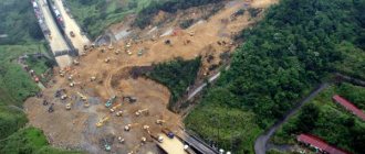
Strong earthquakes leave many traces, especially in the area of the epicenter: the most common are landslides and slides of loose soil and cracks on the earth's surface. The nature of such disturbances is largely determined by the geological structure of the area. In loose and water-saturated soil on steep slopes, landslides and collapses often occur, and the thick layer of water-saturated alluvium in valleys is more easily deformed than hard rocks. On the surface of alluvium, subsidence basins are formed and filled with water. And even not very strong earthquakes are reflected in the terrain.
Displacements along faults or the occurrence of surface ruptures can change the plan and altitude position of individual points of the earth's surface along a fault line, as happened during the 1906 San Francisco earthquake. During the October 1915 earthquake in the Pleasant Valley in Nevada, a ledge 35 km long and up to 4.5 m high formed on the fault. During the May 1940 earthquake in the Imperial Valley in California, movements occurred along a 55-kilometer section of the fault, and horizontal displacements of up to 4 were observed .5 m. As a result of the Assam earthquake (India) in June 1897 in the epicentral region, the height of the area changed by no less than 3 m.
Significant surface deformations can be traced not only near faults and lead to a change in the direction of river flow, damming or rupture of watercourses, disruption of the regime of water sources, and some of them temporarily or permanently cease to function, but at the same time new ones may appear. Wells and boreholes are filled with mud, and the water level in them changes noticeably. During strong earthquakes, water, liquid mud or sand can be ejected from the ground in fountains.
When moving along faults, damage occurs to roads and railways, buildings, bridges and other engineering structures. However, well-built buildings rarely collapse completely. Typically, the degree of destruction is directly dependent on the type of structure and the geological structure of the area. During earthquakes of moderate strength, partial damage to buildings can occur, and if they are poorly designed or poorly constructed, then their complete destruction is possible.
During very strong shocks, structures built without taking into account seismic hazards can collapse and suffer severe damage. Typically, one- and two-story buildings do not collapse unless they have very heavy roofs. However, it happens that they move from the foundations and often their plaster cracks and falls off.
Differential movements can cause bridges to move from their supports and cause utilities and water pipes to break. During intense vibrations, pipes laid in the ground can “fold”, sticking into one another, or bend, coming to the surface, and railway rails become deformed. In earthquake-prone areas, structures must be designed and built in compliance with the building codes adopted for the given area in accordance with the seismic zoning map.
In densely populated areas, almost more damage than the earthquakes themselves are caused by fires that occur as a result of ruptures of gas pipelines and power lines, overturning of stoves, stoves and various heating devices. Fighting fires is complicated by the fact that the water supply is damaged and the streets are impassable due to the resulting rubble.
Rules of conduct during an earthquake
It is very important for every person to know the rules of behavior during an earthquake in order not to get confused at the most crucial moment and to try, if possible, to provide themselves and others with the maximum possible help. First of all, this applies to those people who permanently live or are temporarily located in seismically hazardous areas, who must always be prepared
Best articles: Names for cats or cats with black coat color - alphabetically from A to Z
Rules of conduct during an earthquake
In order for an earthquake not to take all important documents and savings by surprise, a first aid kit, as well as a flashlight, must be stored in one place, and always keep in mind an approximate plan of action when you are in any of the possible places where you could be. Also, do not store heavy, sharp or nuclear-containing substances on top shelves and cabinets.
If you receive a message about a strong earthquake and the need to evacuate, if you are not at home and you have a small amount of time, you need to immediately go to your home, collect all the necessary documents and things, turn off the water, electricity and gas and close the doors. After which it is necessary to leave the populated area as soon as possible and go to a safer place.
During an earthquake, it is very important to pull yourself together, suppress panic and confusion, and try to act rationally, as quickly and productively as possible, in order to have a greater chance of saving yourself from damage. First of all, if you are indoors, you need to try to get out of the premises as soon as possible, while capturing and, if possible, go to a more open area where there is no electricity, buildings or trees nearby.
If you exit from higher floors, it is better to do so by stairs rather than by elevator.
If you cannot leave the premises, you must find the safest place in it. This could be a place near a load-bearing wall that is not overloaded with objects, a doorway, or under a strong table or bed that will be able to protect from falling objects. Under no circumstances should you stand near windows, shelves or heavy objects; you should also not use gas or electricity.
If there are children near you, first of all you need to try to calm them down, find them a secluded place, or, if you are in an open area, under no circumstances let them out of sight and keep them close to you.
If an earthquake finds you in a car, you also need to try to find a more open area, not cluttered with poles, various plantings and billboards intended for advertising, stop the car, open the door and stay in it until the tremors are over.
Related phenomena.
Sometimes tremors are accompanied by a clearly audible low hum when the frequency of seismic vibrations lies in the range perceived by the human ear; sometimes such sounds are heard in the absence of tremors. They are quite common in some areas, although significant earthquakes are very rare. There are also numerous reports of the appearance of a glow during strong earthquakes. There is no generally accepted explanation for such phenomena yet. Tsunamis (large sea waves) occur when rapid vertical deformations of the seabed occur during underwater earthquakes. Tsunamis propagate in the deep oceans at speeds of 400–800 km/h and can cause destruction on coastlines thousands of kilometers from the epicenter. On the shores close to the epicenter, these waves sometimes reach a height of 30 m.
During many strong earthquakes, in addition to the main shocks, foreshocks (preceding earthquakes) and numerous aftershocks (earthquakes following the main shock) are recorded. Aftershocks are usually weaker than the mainshock and can recur over weeks or even years, becoming less and less frequent.
The principle of earthquakes
What causes earthquakes? Earthquakes can be caused by both natural causes and man-made ones.
Most often, earthquakes occur due to faults in tectonic plates and their rapid displacement. For a person, a fault is not noticeable until the moment when the energy generated from the rupture of rocks begins to break out to the surface.
How do earthquakes occur due to unnatural causes? Quite often, a person, through his carelessness, provokes the appearance of artificial tremors, which in their power are not at all inferior to natural ones. Among these reasons are the following:
- — explosions;
- — overfilling of reservoirs;
- — above-ground (underground) nuclear explosion;
- — collapses in mines.
Where a tectonic plate breaks is the source of an earthquake. Not only the strength of the potential push, but also its duration will depend on the depth of its location. If the source is located 100 kilometers from the surface, then its strength will be more than noticeable. Most likely, this earthquake will lead to the destruction of houses and buildings. Occurring in the sea, such earthquakes cause tsunamis. However, the source can be located much deeper - 700 and 800 kilometers. Such phenomena are not dangerous and can only be recorded with the help of special devices - seismographs.
The place where the earthquake is most powerful is called the epicenter. It is this piece of land that is considered the most dangerous for the existence of all living things.
Geographical distribution of earthquakes.
Most earthquakes are concentrated in two long, narrow zones. One of them frames the Pacific Ocean, and the second stretches from the Azores east to Southeast Asia.
The Pacific seismic zone runs along the west coast of South America. In Central America it splits into two branches, one following the island arc of the West Indies, and the other continuing north, expanding within the United States, to the western ranges of the Rocky Mountains. Further, this zone passes through the Aleutian Islands to Kamchatka and then through the Japanese Islands, the Philippines, New Guinea and the islands of the southwestern Pacific Ocean to New Zealand and Antarctica.
The second zone from the Azores extends east through the Alps and Turkey. In southern Asia, it expands and then narrows and changes direction to the meridional, passes through the territory of Myanmar, the islands of Sumatra and Java and connects with the circum-Pacific zone in the region of New Guinea.
There is also a smaller zone in the central part of the Atlantic Ocean, following along the Mid-Atlantic Ridge.
There are a number of areas where earthquakes occur quite frequently. These include East Africa, the Indian Ocean and in North America the valley of the St. River. Lawrence and northeastern USA.
Sometimes strong earthquakes occur in areas that are considered inactive, such as in Charleston, South Carolina in 1886.
Compared to shallow-focus earthquakes, deep-focus earthquakes have a more limited distribution. They have not been recorded within the Pacific zone from southern Mexico to the Aleutian Islands, and in the Mediterranean zone - west of the Carpathians. Deep-focus earthquakes are characteristic of the western edge of the Pacific Ocean, Southeast Asia and the western coast of South America. The zone with deep-focus sources is usually located along the zone of shallow-focus earthquakes on the continental side.
Volcanic causes of earthquakes
One of the causes of earthquakes is volcanoes. Although they do not produce strong vibrations of the earth, they last quite a long time. The reasons for the tremors are related to the fact that deep in the depths of the volcano the tension formed by lava and volcanic gases increases. As a rule, volcanic earthquakes last for weeks or even months.
However, history knows cases of tragic earthquakes of this type. An example is the Krakatoa volcano, located in Indonesia, which erupted in 1883.
Krakatoa still gets excited sometimes. Real photo.
The force of its explosion was at least 10 thousand times greater than the force of the atomic bomb dropped on Hiroshima. The mountain itself was almost completely destroyed, and the island split into three small parts. Two-thirds of the land disappeared under water, and the rising tsunami destroyed everyone who still had a chance to escape. More than 36,000 people died.
Earthquake forecast.
To improve the accuracy of earthquake forecasts, it is necessary to better understand the mechanisms of stress accumulation in the earth's crust, creep and deformations on faults, to identify the relationships between heat flow from the Earth's interior and the spatial distribution of earthquakes, and also to establish patterns of earthquake recurrence depending on their magnitude.
In many areas of the globe where there is a possibility of strong earthquakes, geodynamic observations are carried out in order to detect earthquake precursors, among which changes in seismic activity, deformation of the earth's crust, anomalies in geomagnetic fields and heat flow, sharp changes in the properties of rocks (electrical, seismic, etc.), geochemical anomalies, water regime disturbances, atmospheric phenomena, as well as abnormal behavior of insects and other animals (biological precursors). This kind of research is carried out at special geodynamic testing sites (for example, Parkfield in California, Garm in Tajikistan, etc.). Since 1960, many seismic stations have been operating, equipped with highly sensitive recording equipment and powerful computers that allow them to quickly process data and determine the location of earthquake sources.
Types of earthquakes
Factors that reveal why earthquakes occur can be tectonic phenomena (movement or deformation of the earth's crust, processes in the planetary mantle), volcanic activity, landslides and other rock movements, engineering and military activities in the territory. The causes of earthquakes are both natural and man-made.
The following describes in more detail the origins of earthquakes.
Tectonic
This category includes the largest part of recorded underground processes. Tectonic earthquakes occur when rocks suddenly shift due to the movement of tectonic plates. We are talking about either the collision of thick continental plates, or the diving of a thin oceanic plate under a thick continental one.
The movement of lithospheric plates is insignificant, usually not more than a couple of centimeters, but it provokes a shift in the rocks above the focus, resulting in the release of a lot of energy. The movement of rocks causes cracks to appear in the ground. Blocks of earth adjacent to these cracks fall apart, become deformed, and objects located on their surface are destroyed.
Technogenic
Due to active human activity, man-made earthquakes occur, and their number increases every year following the intensification of the destructive impact of humans on the planet. Seismologists note that the number of tremors is increasing in areas surrounding large reservoirs, natural resource extraction zones, active and depleted mines and quarries, and other engineering structures.
The frequent occurrence of underground processes in the area where reservoirs are located is due to the fact that a significant mass of water puts pressure on the earth’s crust and erodes rocks.
Volcanic
This type of earthquake is distinguished by its weak manifestation, but its duration of existence. Earth vibrations do not cause much destruction, and catastrophic consequences are rare.
A powerful shift in the earth's crust as a result of volcanic activity occurred in the 19th century in Indonesia. The erupting volcano Krakatoa split the Indonesian island of the same name into three parts. The tremors were so powerful that the volcano half collapsed, and two parts of the island went into the water. Further, a tsunami hit the coast, destroying the entire population who did not manage to leave the ill-fated island in time.
Landslide
The causes of underground vibrations can be large slope failures and landslides. Such earthquakes are also not intense, but the danger lies in the collapse of huge soil layers.
The most terrible landslide earthquake is considered to have occurred in Peru in January 1062. A giant avalanche, consisting of mud and melted snow, came down from Mount Huascaran, provoked vibrations in the earth’s crust, and wiped out several settlements. More than 18 thousand people died.
Best articles: Which spider is the most terrible and strange on Earth - photos and descriptions of scary-looking spiders
Underwater
When the tectonic plates that form the ocean floor collide, underwater earthquakes occur. With a shallow focus and a magnitude above 7 points, the seismic process is extremely dangerous, since it provokes a tsunami. When the oceanic crust shifts, some parts of the bottom rise, others fall, and as a result, the water mass, trying to return to its original position, begins to move vertically. This is how giant waves directed towards the coast are born - tsunamis.
Earthquakes accompanied by tsunamis often have catastrophic consequences. So, several years ago, a tectonic plate shifted in the Indian Ocean, leading to the formation of a huge wave. The tsunami hit the Indian and Indonesian coasts, killing more than 200 thousand local residents.
Artificial
We are talking about seismic processes provoked by human engineering and military activities. Artificial earthquakes occur as a result of rocket launches, well drilling, and the development of oil and gas-bearing underground formations. Thus, during the demonstration launch of nuclear missiles by the DPRK in different parts of the planet, seismographs recorded tremors of moderate intensity.
From the impact of cosmic bodies
When a large space object, having overcome the earth's atmosphere, crashes into the surface of the planet, it explodes, causing a shock wave to be formed that spreads both in the ground and in the air over considerable distances.