The concept of scale and its types
Map scale is the ratio of the length of a segment on the map to its actual length on the ground.
Scale (from the German Stab - stick) is the ratio of the length of a segment on a map, plan, aerial or satellite image to its actual length on the ground.
Let's consider the types of scales.
Numerical scale
This is a scale expressed as a fraction, where the numerator is one and the denominator is a number indicating how many times the image is reduced.
Numerical scale is a scale expressed as a fraction in which:
- the numerator is equal to one,
- the denominator is equal to the number showing how many times the linear dimensions on the map are reduced.
Named (verbal) scale
This is a type of scale, a verbal indication of what distance on the ground corresponds to 1 cm on a map, plan, photograph.
A named scale is expressed by named numbers indicating the lengths of mutually corresponding segments on the map and in nature.
For example, there are 5 kilometers in 1 centimeter (5 kilometers in 1 cm).
Linear scale
This is an auxiliary measuring ruler applied to maps to facilitate the measurement of distances.
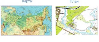
Plan scale and map scale
The scale of the plan is the same at all its points.
The map scale at each point has its own particular value, depending on the latitude and longitude of the given point. Therefore, its strict numerical characteristic is the numerical scale - the ratio of the length of an infinitesimal segment D on the map to the length of the corresponding infinitesimal segment on the surface of the ellipsoid of the globe.
However, for practical measurements on a map, its main scale is used.
Methods for recording scale
The scale can be plotted on a map in the following ways:
- Numerical scale, when the relationship between the lines on the map and the terrain depicted on the map is written as a linear fraction separated by a colon. On the left is traditionally placed $1$, on the right is a number indicating the scale.
Example 1
The scale written as $1:100\000$ shows that $1$ unit of length on the map corresponds to $100\000$ units on the ground. On a map of this scale, a line $1$ cm long will depict an object 1000 meters long.
- The linear method of displaying scale is a graphic image in the form of a strip divided into units of length on the ground. To construct a linear scale on a straight line, several segments of equal length are laid out one after another, serving as the basis of the scale.
Typically, the base corresponds to an integer number of hundreds of meters or kilometers. To make measurements more accurately using this method of indicating the scale, the first base on the left is divided into several smaller parts. For example, on a map of scale $1:100\000$, the minimum division of the linear scale will correspond to one hundred meters on the map. To determine the distance on the map, you need to transfer it using a measuring compass to the scale display.
- Named scale. Often on the map you can also find a text entry about the scale of this type: “Map scale is more than $1$ km in $1$ cm.” This is the named scale.
Are you an expert in this subject area? We invite you to become the author of the Directory Working Conditions
Note 1
Many maps show scale in more than one or all three ways. The scale of the map can be indicated in the legend or in the corner of the map.
Forms of expression of scale
The designation of scale on maps and plans has three forms - numerical, named and linear scales.
The numerical scale is expressed as a fraction in which:
- numerator is one,
- denominator M – a number showing how many times the dimensions on the map or plan are reduced (1:M)
In Russia, standard numerical scales have been adopted for topographic maps
- 1:1 000 000
- 1:500 000
- 1:300 000
- 1:200 000
- 1:100 000
- 1:50 000
- 1:25 000
- 1:10 000
- For special purposes, topographic maps are also created at scales of 1:5,000 and 1:2,000
Main scales of topographic plans in Russia
- 1:5000
- 1:2000
- 1:1000
- 1:500
In land management practice, land use plans are most often drawn up at scales of 1:10,000 and 1:25,000 , and sometimes - 1:50,000.
When comparing different numerical scales, the smaller one is the one with the larger denominator M , and, conversely, the smaller the denominator M , the larger the scale of the plan or map.
Thus, a scale of 1:10000 is larger than a scale of 1:100000 , and a scale of 1:50000 is smaller than a scale of 1:10000 .
Note
The scales used in topographic maps are established by the Order of the Ministry of Economic Development of the Russian Federation “On approval of requirements for state topographic maps and state topographic plans, including requirements for the composition of information displayed on them, for the symbols of this information, requirements for the accuracy of state topographic maps and state topographic plans , to the format of their presentation in electronic form, requirements for the content of topographic maps, including relief maps” (No. 271 of June 6, 2021, as amended on December 11, 2021).
Scales of topographic plans
Scale is one of the most important characteristics of a topographic plan; it shows the relationship of objects on the plan to objects on the real terrain, that is, how much smaller the image on the plan is of the situation in reality. The variety of scales can be explained by the fact that each type is designed to solve specific problems. The larger the scale denominator, the smaller the plan and the larger area of territory it covers. Using a scale, two problems are solved: using measured segments on the plan, corresponding segments on the ground are determined, and using measured distances on the ground, corresponding segments on the plan are found.
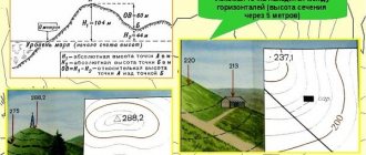
Scales are divided into two main types, as mentioned earlier these are the scales of topographic plans and the scales of topographic maps. By drawing scales on maps, one can distinguish: linear, numerical and named. Figure 1 clearly shows their visual differences. In topographical plans, a numerical scale is often used, since it is more compact. And linear and named are more often found on various maps.
Figure 1 - Types of scales
It is especially important to note the graphic accuracy of plans of different scales. This concept means the error in determining the position of an object on the plan relative to geodetic points. In other words, with what accuracy can you find out the coordinates of an object on the plan. The human eye is designed in such a way that from a normal distance it will be problematic to read adjacent lines on a map, provided that the distance between them is less than 0.1 mm - the lines will merge into one. Accordingly, the value of 0.1 mm is the graphical accuracy of changes on the plan. Along with graphical accuracy is the distance on the ground corresponding to this value. This parameter is called scale accuracy. Calculating the scale accuracy is not difficult; to do this, you need to divide the denominator of the numerical scale by 10,000. This means that for a scale of 1:500 the accuracy is 0.05 m or 50 mm.
Let's consider the use of plans of different scales in geodetic production.
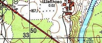
Topographic plans at a scale of 1:5000 are aimed at developing master plans for the creation or reconstruction of large cities, small settlements, and their parts. But the use of plans of this scale is not limited to this; they are widely used in mineral exploration, land management and land cadastre. When developing technical projects and working drawings, for desk routing of roads and railways, plans are also used in the design and survey of various kinds of engineering structures. An example of a plan at this scale is shown in Figure 2. Based on topographic plans at a scale of 1:5000, maps of smaller scales are created.
Figure 2 - Fragments of a topographic plan at a scale of 1:5000
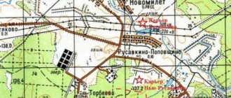
Let's consider the purpose of a topographic plan at a scale of 1:2000, a fragment of which is shown in Figure 3. Basically, topoplans of this scale are used for:
- development of master plans for villages;
- for drawing up a detailed planning project, technical projects, layout drawings of landscaping elements;
- detailed exploration of deposits of various minerals;
- creation of technical projects for the construction and reconstruction of roads and railways, pipelines, engineering structures in the field of shipping, irrigation, hydrology.
Figure 3 - Fragments of a topographic plan at a scale of 1:2000
Topographic plans at a scale of 1:1000 are intended for:
- drawing up a master plan and working drawings when designing low-rise and settlement construction in built-up and undeveloped areas;
- solutions for vertical planning and landscaping projects; drawing up plans for existing underground networks and structures, and linking buildings and structures to construction sites;
- detailed exploration and calculation of mineral reserves;
- design of hydraulic structures and geological services for mining enterprises.
Figure 4 shows fragments of such a plan.
Figure 4 - Fragments of a topographic plan at a scale of 1:1000
To draw up an executive, master plan for a construction site and working drawings of a multi-storey capital development with a dense network of underground communications, industrial enterprises, to solve the vertical layout, draw up plans for underground networks and structures and link buildings and structures to construction sites in the built-up areas of the city, topographic scale plans are intended 1:500. An example of a topographic plan M 1:500 is shown in Figure 5.
In most cases, due to their widespread use, especially in construction, 1:500 scale plans are used.
Figure 5 - Fragment of a topographic plan at a scale of 1:500
A few words need to be said about topoplans of scales 1:200 and 1:100, which are created during large-scale photography. Their use is associated with the presence of a complex situation, multiple small circuits and a dense network of underground communications. Plans of this scale are also used for tree taxation.
Scale accuracy
The maximum possibility of measuring and constructing segments on maps and plans is limited to 0.01 cm. The corresponding number of meters of terrain on the scale of a map or plan represents the maximum graphic accuracy of a given scale.
Since the accuracy of the scale expresses the length of the horizontal location of the terrain line in meters, to determine it, the denominator of the numerical scale should be divided by 10,000 (1 m contains 10,000 segments of 0.01 cm). So, for a map at a scale of 1:25,000, the scale accuracy is 2.5 m; for a 1:100,000 map - 10 m, etc.
Scales of topographic maps
| numerical map scale | card name | 1 cm on the map corresponds to a distance on the ground | 1 cm2 on the map corresponds to an area on the ground |
| 1:5 000 | five thousandth | 50 m | 0.25 ha |
| 1:10 000 | ten-thousandth | 100 m | 1 ha |
| 1:25 000 | twenty-five thousandth | 250 m | 6.25 ha |
| 1:50 000 | fifty thousandth | 500 m | 25 hectares |
| 1:1100 000 | hundred thousandth | 1 km | 1 km2 |
| 1:200 000 | two hundred thousandth | 2 km | 4 km2 |
| 1:500 000 | five hundred thousandth, or half a millionth | 5 km | 25 km2 |
| 1:1000000 | millionth | 10 km | 100 km2 |
Below are the numerical scales of the maps and the corresponding named scales:
Scale 1:100,000
- 1 mm on the map – 100 m (0.1 km) on the ground
- 1 cm on the map – 1000 m (1 km) on the ground
- 10 cm on the map – 10,000 m (10 km) on the ground
Scale 1:10000
- 1 mm on the map – 10 m (0.01 km) on the ground
- 1 cm on the map – 100 m (0.1 km) on the ground
- 10 cm on the map – 1000 m (1 km) on the ground
Scale 1:5000
- 1 mm on the map – 5 m (0.005 km) on the ground
- 1 cm on the map – 50 m (0.05 km) on the ground
- 10 cm on the map – 500 m (0.5 km) on the ground
Scale 1:2000
- 1 mm on the map – 2 m (0.002 km) on the ground
- 1 cm on the map – 20 m (0.02 km) on the ground
- 10 cm on the map – 200 m (0.2 km) on the ground
Scale 1:1000
- 1 mm on the map – 100 cm (1 m) on the ground
- 1 cm on the map – 1000 cm (10 m) on the ground
- 10 cm on the map – 100 m on the ground
Scale 1:500
- 1 mm on the map – 50 cm (0.5 m) on the ground
- 1 cm on the map – 5 m on the ground
- 10 cm on the map – 50 m on the ground
Scale 1:200
- 1 mm on the map – 0.2 m (20 cm) on the ground
- 1 cm on the map – 2 m (200 cm) on the ground
- 10 cm on the map – 20 m (0.2 km) on the ground
Scale 1:100
- 1 mm on the map – 0.1 m (10 cm) on the ground
- 1 cm on the map – 1 m (100 cm) on the ground
- 10 cm on the map – 10 m (0.01 km) on the ground
Example 1
Convert the numerical scale of the map to a named one:
- 1:200 000
- 1:10 000 000
- 1:25 000
Solution:
To more easily convert a numerical scale into a named one, you need to count how many zeros the number in the denominator ends with.
For example, on a scale of 1:500,000, there are five zeros in the denominator after the number 5.
If after the number in the denominator there are five more zeros, then by covering (with a finger, a pen or simply crossing out) the five zeros, we get the number of kilometers on the ground corresponding to 1 centimeter on the map.
Example for scale 1:500,000
The denominator after the number has five zeros. Closing them, we get for a named scale: 1 cm on the map is 5 kilometers on the ground.
If there are less than five zeros after the number in the denominator, then by closing two zeros, we get the number of meters on the ground corresponding to 1 centimeter on the map.
we close two zeros in the denominator of a scale of 1:10,000
in 1 cm – 100 m.
Answers:
- 1 cm – 2 km
- 1 cm – 100 km
- in 1 cm – 250 m
Use a ruler and place it on the maps to make it easier to measure distances.
Example 2
Convert the named scale to a numerical one:
- in 1 cm – 500 m
- 1 cm – 10 km
- 1 cm – 250 km
Solution:
To more easily convert a named scale to a numerical one, you need to convert the distance on the ground indicated in the named scale into centimeters.
If the distance on the ground is expressed in meters, then to obtain the denominator of the numerical scale, you need to assign two zeros, if in kilometers, then five zeros.
For example, for a named scale of 1 cm - 100 m, the distance on the ground is expressed in meters, so for the numerical scale we assign two zeros and get: 1:10 000.
For a scale of 1 cm - 5 km, we add five zeros to the five and get: 1:500 000.
Answers:
- 1:50 000
- 1:1 000 000
- 1:25 000 000
Types of maps depending on scale
Depending on the scale, maps are conventionally divided into the following types:
- topographic plans 1:400 – 1:5 000
- large-scale topographic maps 1:10,000 – 1:100,000
- medium-scale topographic maps from 1:200,000 – 1:1,000,000
- small-scale topographic maps less than 1:1,000,000
Types of maps depending on scale
Depending on the scale, maps are divided into:
- Large-scale – scale $1:100\000$ or less. With the help of such maps, small states, administrative-territorial units or settlements are depicted.
- Medium-scale maps have scales ranging from $1:100\000$ to $1:1\000\000$. As a rule, these are maps of large states or natural objects - islands, peninsulas, seas.
- Small-scale maps . The scale of such maps is more than $1:1\000\000$. Such maps depict individual parts of the world, continents or the entire world.
Finished works on a similar topic
Coursework Map scale 400 ₽ Abstract Map scale 250 ₽ Test paper Map scale 230 ₽
Receive completed work or specialist advice on your educational project Find out the cost
In the name of the scale type, coarseness indicates how large objects are displayed. Those. on a small-scale map, entire countries will appear small in area, and vice versa, on a large-scale map, objects are depicted larger.
Note 2
Regarding the numerical recording of the scale, the following logical rule applies: the larger the number on the right side of the fraction, the smaller the scale.
Topographic map
Topographical maps are those whose content allows them to solve various technical problems.
Maps are either the result of direct topographic survey of the area, or are compiled from existing cartographic materials.
The terrain on the map is depicted at a certain scale.
The smaller the denominator of a numerical scale, the larger the scale. Plans are drawn up on a large scale, and maps are drawn up on a small scale.
Maps take into account the “spherical shape” of the earth, but plans do not. Because of this, plans are not drawn up for areas larger than 400 km² (that is, areas of land approximately 20 km x 20 km).
- Standard scales for topographic maps
The following scales of topographic maps are accepted in our country:
- 1:1 000 000
- 1:500 000
- 1:200 000
- 1:100 000
- 1:50 000
- 1:25 000
- 1:10 000
This series of scales is called standard. Previously, this series included scales of 1:300,000, 1:5000 and 1:2000.
- Large scale topographic maps
Scale maps:
- 1:10,000 (1cm =100m)
- 1:25,000 (1cm = 100m)
- 1:50,000 (1cm = 500m)
- 1:100,000 (1cm =1000 m)
are called large-scale.
- Other scales and maps
Topographic maps of the territory of Russia up to a scale of 1:50,000 inclusive are classified, topographic maps of a scale of 1:100,000 are chipboard (for official use), and smaller ones are not classified.
Currently, there is a methodology for creating topographic maps and plans of any scale that are not classified and intended for public use.
A tale about a map on a scale of 1:1
Once upon a time there lived a Capricious King. One day he traveled around his kingdom and saw how large and beautiful his land was. He saw winding rivers, huge lakes, high mountains and wonderful cities. He became proud of his possessions and wanted the whole world to know about them.
And so, the Capricious King ordered cartographers to create a map of the kingdom. The cartographers worked for a whole year and finally presented the King with a wonderful map, on which all the mountain ranges, large cities and large lakes and rivers were marked.
However, the Capricious King was not satisfied. He wanted to see on the map not only the outlines of mountain ranges, but also an image of each mountain peak. Not only large cities, but also small ones and villages. He wanted to see small rivers flowing into rivers.
The cartographers set to work again, worked for many years and drew another map, twice the size of the previous one. But now the King wanted the map to show passes between mountain peaks, small lakes in the forests, streams, and peasant houses on the outskirts of villages. Cartographers drew more and more maps.
The Capricious King died before the work was completed. The heirs, one after another, ascended the throne and died in turn, and the map was drawn up and drawn up. Each king hired new cartographers to map the kingdom, but each time he was dissatisfied with the fruits of his labor, finding the map insufficiently detailed.
Finally, the cartographers drew the Incredible Map! It depicted the entire kingdom in great detail - and was exactly the same size as the kingdom itself. Now no one could tell the difference between the map and the kingdom.
Where were the Capricious Kings going to keep their wonderful map? The casket is not enough for such a map. You will need a huge room like a hangar, and in it the map will lie in many layers. But is such a card necessary? After all, a life-size map can be successfully replaced by the terrain itself))))
It is useful to familiarize yourself with this
- You can familiarize yourself with the units of measurement of land areas used in Russia here.
- For those who are interested in the possibility of increasing the area of land plots for individual housing construction, private household plots, gardening, vegetable farming, owned, it is useful to familiarize yourself with the procedure for registering additions.
- From January 1, 2021, the exact boundaries of the plot must be recorded in the cadastral passport, since it will simply be impossible to buy, sell, mortgage or donate land without an accurate description of the boundaries. This is regulated by amendments to the Land Code. A total revision of borders at the initiative of municipalities began on June 1, 2015.
- On March 1, 2015, the new Federal Law “On Amendments to the Land Code of the Russian Federation and certain legislative acts of the Russian Federation” (N 171-FZ dated June 23, 2014) came into force, according to which, in particular, the procedure for purchasing land plots has been simplified from municipalities. You can familiarize yourself with the main provisions of the law here.
- With regard to the registration of houses, bathhouses, garages and other buildings on land plots owned by citizens, the new dacha amnesty will improve the situation.