The definition of the concept of height of a relief section should begin with what a horizontal line is. This term refers to a closed curved line through which the contour of surface points located at the same level relative to the sea is displayed.
For the first time, cartographers from France and Russia began to depict the relief using contour lines at the beginning of the 18th century. This is represented as follows:
- the relief is intersected by planes, each of which is parallel to the horizontal;
- the distances between horizontal lines (section heights) are the same;
- the intersection points of the relief with the horizontal lines are projected onto a plane and plotted on the plan of the described territory.
Also called a line of equal levels relative to the sea, since it unites points that lie at the same level relative to the sea.
Basic terms
The height of the relief section is defined as the distance between adjacent planes forming horizontal lines (the difference in levels of adjacent planes). Based on the display of these lines, the following term is defined that describes the features of the terrain surface - laying. It is defined as the distance between adjacent horizontal lines plotted on the diagram.
You can determine the direction of the slope at its origin by imagining a perpendicular to the horizontal, which lies at its base. The amount of slope (angle of slope) is inversely proportional to the location. Here the slope is the hypotenuse of a right triangle, the legs of which are equal to the location and height of the section. Accordingly, the slope is always greater than the foundation.
On maps of the same scale, it is customary to display the same cross-sectional size. As the scale increases, it grows, and the angle of the slope decreases. For maps of plains and foothills this figure is half that for mountainous areas (see Table 1).
Table 1. The height of the section depending on the map scale.
| scale | section height, m | |
| on the plain, in the foothills | in the mountains | |
| 1:10000 | 2,5 | 5 |
| 1:25000 | 5 | 10 |
| 1:50000 | 10 | 20 |
| 1:10000 | 20 | 40 |
If the map (plan) is compiled based on materials from a larger-scale survey, the section height is taken in accordance with the data of the source materials.
On plans intended for engineering and hydrological work, the height of the cross-section of the bottom relief is laid out similarly to the indicator for land on a map of a similar scale.
If a map with detailed and special measurements is needed, it is compiled based on the following values:
- 0.5 meters for depths up to 10 meters (usual measurement);
- 0.5 meters for depths up to 5 meters (reconnaissance and lightweight measurements);
- 1 meter for depths over 5 meters (reconnaissance and lightweight measurements).
When mapping areas with very steep slopes, the section height can be increased. This is done so that the image is not cluttered with too many lines located close to each other.
It is not always possible to convey the shape of the relief using only horizontal lines. To display terrain features, additional diagrams can be used that display bends, slopes, saddles and other features of the earth's surface in a section.
Horizontal
The horizontal line is a closed line depicting a horizontal contour of unevenness on the map, all points of which on the ground are located at the same height above sea level (line of equal heights).
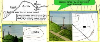
Using the example of Figure 1, we will consider the essence of depicting relief with horizontal lines. The figure shows an island with vertices A and B and coastlines D, E, F. The closed curve d, e, f is a plan view of the coastline. Since the coastline is a cross-section of the island by the level surface of the ocean, the image of this line on the map is a zero horizontal line, all points of which have a height equal to zero.
Figure 1. – The essence of depicting relief with horizontal lines
Let us assume that the ocean level has risen to a height h, then a new section of the island is formed by an imaginary cutting plane h–h. By designing this section using plumb lines, we obtain on the map an image of the first horizontal line, all points of which have height h. In the same way, you can get an image on the map of other sections made at heights 2h, 3h, 4h, etc. As a result, the map will depict the island's relief with contour lines. In this case, the relief of the island is depicted by three horizontal lines, covering the entire island, and two horizontal lines, covering each of the peaks separately. Top A is slightly higher than 4h, and peak B is slightly higher than 3h relative to ocean level. The slopes of hill A are steeper than the slopes of hill B, so in the first case the contour lines on the map are located closer to each other than in the second.
From Figure 1 it is clear that the method of depicting the relief with horizontal lines allows you to correctly not only display the shapes of the relief, but also determine the heights of individual points of the earth's surface based on the height of the relief section and the steepness of the slopes. On topographic maps, horizontal lines are drawn with a thickness of 0.1 mm.
Miass
- a city within the Chelyabinsk region (Russia).
The city is located on the Miass River at the foot of the Ilmen Mountains, 96 km southwest of the regional center - Chelyabinsk. Not far from the city is the Ilmensky Mineralogical Reserve.
The city's territory is 111.9 km2, the number of inhabitants is 151.8 thousand people (according to the results of the 2010 All-Russian Population Census), the total length of roads is 454 km. Railway station on the Ufa-Chelyabinsk line. The area of the housing stock is 3,488 thousand m2.
Day of the city
Year of foundation of the city of Miass: 1773
.
City Day is celebrated on November 18
:
- in 2011 it is the third Friday of the month (238 years);
- in 2012 - the third Sunday of the month (239 years);
- in 2013 - the third Monday of the month (240 years);
- in 2014 - the third Tuesday of the month (241);
- in 2015 - the third Wednesday of the month (242 years);
- in 2021 - third Friday of the month (243 years);
- in 2021 - third Saturday of the month (244 years);
- in 2021 - third Sunday of the month (245 years);
- in 2021 - third Monday of the month (246 years);
- in 2021 - third Wednesday of the month (247 years);
- in 2021 - third Thursday of the month (248 years);
- in 2022 - third Friday of the month (249 years);
- in 2023 - the third Saturday of the month (250 years).
Story
The history of the formation of Miass is typical for the cities of the mining zone of the Chelyabinsk region.
The first settlement appeared in 1773
, a native of the Tula merchant class, L. Luginin began the construction of a copper smelter on the Miass River near the Chashkovsky Mountains, where rich deposits of copper ore were discovered.
Construction work began in 1773 without official permission
.
The plant was launched on August 12, 1777
, and the date of signing the petition for construction by Empress Catherine II -
November 18, 1773
- is celebrated as the founding day of Miass.
In the first decade of its existence, the plant gradually increased production volumes: from 1777 to 1780
12.9 thousand pounds of copper were produced,
in 1781-1790
- 40.2 thousand pounds.
In 1787,
the plant passed to the founder’s nephews, Ivan and Nikolai Maksimovich Luginin.
In 1798
I.M.
Luginin sold the enterprise to the treasury, and in 1799-1800
copper smelting was not carried out.
And by the middle of the 19th century,
copper production decreased, and the maintenance of the plant became unprofitable, as a result of which it was closed.
The economic development of Miass was facilitated by the development of gold deposits. In the first half of the 19th century
the entire valley of the Miass River turned into a huge gold mine.
In 1836,
54 mines and 23 gold deposits were being developed here.
The most famous is the Tsarevo-Alexandrovsky (Leninsky) mine. In 1824
Shikhtmeister Medger discovered a placer, which turned out to be the richest: washing the sand showed the content of “more than a pound of gold in a hundred poods.”
In the summer of 1824,
a mine was founded here. During one of his trips, Emperor Alexander I came here to the gold mines. He wanted to try his luck as a simple gold digger, and the emperor was lucky; on the same day he found a nugget weighing 3 kilograms. In honor of this visit, the mine got its name.
It ranked first among the mines of the Miass region in terms of wealth and number of large nuggets found; in one year alone, 52 pieces were found here; in 1842, artisan Nikifor Syutkin found one of the world’s largest nuggets, the “Big Triangle,” weighing 36.21 kilograms.
From the middle of the 19th century
The Miass gold mining partnership of Count Levashov, Daragan and Co. appears. The shareholders were representatives of the St. Petersburg aristocracy. The boundaries of the partnership's allotments included all groups of state-owned mines with a total area of 23,394 hectares. The partnership allowed prospectors to develop placers, who provided more than half of all production.
The beginning of the partnership’s activities was associated with the introduction of new technical advances in gold mining production, which, along with the ongoing development of rich placers, made it possible to achieve the flourishing of gold mining in the Miass region.
At this time, the history of the city is closely connected with the name of Yegor Mitrofanovich Simonov, who, having gone from a simple prospector to the owner of the mines, became the richest man in the city. Simonov made a great contribution to the development of the city.
Gold mining remained the main city-forming industry until the beginning of the 20th century
. After nationalization, large associations collapsed, and they began to mainly conduct insignificant artisanal mines.
During the First World War (1915)
The tsarist government evacuated the English sawtooth factory from Riga to Miass.
A year later, the Miass sawmill was launched, which for a long time was the leading enterprise in the industry in the country and one of the best in the world. The issue of granting city status to the Miass plant was decided in December 1919 at a congress of thirteen volost revolutionary committees of the Troitsk district of the Chelyabinsk region, held in Miass
(the inconvenience of administrative subordination to Troitsk hampered the development of the economic life of the plant).
Since that time, Miass first became a provincial town (that is, without a county), and then a county town. In 1926, Miass received city status. In 1926
, in the city, in addition to the sawmill and the mines of the Uralzoloto trust, there were a number of small enterprises, such as the mining department of the Zlatoust Metallurgical Plant, which was engaged in the extraction of talc and other non-metallic minerals, the Severo-Ilmensky and Chernorechensky peat bogs, three state mills, sheepskin fur factory, leather factory, printing house, sawmill power plant.
The industrialization of the country made it possible to technically re-equip the gold industry. built in 1932
on the outskirts of Miass increased the power supply of gold mining enterprises.
In the same year, a floating gold factory, the first electric dredge, was launched at the Leninsky mine. Since 1933,
the mines of a number of mines also came into operation.
The timber industry also developed greatly in the first half of the 20th century Miass had previously been a major supplier of timber: in the vicinity of Turgoyak, logs, firewood, and coal were burned for the Zlatoust and Miass factories. With the creation of the Miass leprom farm, commercial wood, charcoal, fastening material, and sleepers are sent to enterprises in the Southern Urals. Part of the forest was rafted down the mountain rivers Kushtumga and Suhokamenka.
Spring 1939
Construction of the central part of the city began.
November 3, 1941
The State Defense Committee decided to organize automotive production in Miass.
For this purpose, the Stalin Automotive Plant (ZIS) was evacuated from Moscow. In 1943,
the enterprise was renamed the Miass Automobile Plant, and
on June 21, 1944
- the Ural Automobile Plant.
At first, the plant produced engines and gearboxes, and on July 8, 1944
The first Ural car ZIS-5 rolled off the assembly line. The first batch of cars was sent to the front, and the famous Katyushas began to be mounted on them. In the post-war years, the Ural Automobile Plant continued to successfully develop production and produce new Ural models. In total, 1 million 270 thousand cars rolled off the UralAZ assembly line from the moment of launch until the end of the 20th century. The Russian-Italian joint venture Iveco-UralAZ has been successfully operating for many years, producing heavy-duty vehicles.
Almost simultaneously with the automobile plant, the Moskovsky workshop was evacuated from the capital to Miass. Already January 15, 1942
Dynamo produced the first products for the front, laying the foundation for a new enterprise in the city - .
In 1950-1960
A wide variety of industries are developing in Miass: construction, mining, motor transport, light and food industries, and railway transport.
Then large enterprises arose: Turgoyak Mining Administration, Krebetsky Crushed Stone, Uralavtostroy Trust. In 1958,
a decision was made to develop and reconstruct the Ural Automobile Plant and the task was set to master the production of heavy-duty off-road vehicles. The Miassians successfully solved a complex technical problem without stopping production. Soon the first three-axle vehicle of the new model, the Ural-375D, rolled off the main assembly line. Cars - Ural all-terrain vehicles, auto parts, files, various electrical equipment, fluxes and talc powder, building materials, marble slabs, crushed stone, clothing, rubber shoes, furniture and other products have become the brand of our Ural city.
Since 1959
The pace of development of Miass accelerated due to the location in its northern part of defense industry enterprises - the State Missile and Scientific and Production Association of Electromechanics.
In 1970-1980
A large-panel house-building plant was built.
At the foot of the Ilmensky ridge, a white-stone building of the central city hospital, a clinic and an obstetrics and gynecology building appeared. In 1973,
the Neptune Hotel welcomed its first guests to the city.
In the Ilmensky State Reserve named after V.I. Lenin, a whole complex of spacious, bright buildings was built, housing the famous mineralogical museum and scientific laboratories. In 1976,
a clinic was put into operation in the Dynamo electrical operator village, a shopping center in the northern part of the city, a new railway station building and many other objects. Great changes occurred in these years in the field of public transport; trolleybuses appeared on the city streets.
May 5, 1982
For the successes achieved by the city's workers in economic and cultural construction, and the significant contribution to ensuring victory over the Nazi invaders in the Great Patriotic War, by Decree of the Presidium of the Supreme Soviet of the USSR, the city of Miass was awarded the Order of the Red Banner of Labor.
In 2003,
173.3 thousand people lived in the city.
Currently, it is one of five cities in the Ural Federal District claiming the status of “Science City”. The surroundings of Miass, including the “Ural pearl” Lake Turgoyak, have today become the site for the implementation of large business projects in the field of skiing, tourism and the recreation industry. The city, surrounded by forests, mountains and many picturesque lakes, attracts travel lovers, as well as the originality of the merchant houses of old Miass, old and restored churches.
Information sources:
- ru.wikipedia.org - Wikipedia: Miass;
- gorod.miass.ru - official website of the Administration of the Miass Urban District;
- calend.ru - Miass: a city in the golden valley.
Additionally on Guenon:
- About the history of which cities can you learn on Guenon?